The USGS Hawaiian Volcano Observatory Is A Trusted Source For The Kilauea Eruption

For accurate, factual alerts and updates, the Hawaiian Volcano Observatory is the most comprehensive, reliable news source you could possibly go to.
Since 1983, the Kilauea volcano on the Big Island of Hawai’i has been actively erupting. Since early May, however, the eruption has intensified tremendously. On May 3, 2018, a number of new lava vents opened up beneath the summit. Seismic activity had increased as of April 30th, which culminated in a strong earthquake of magnitude 6.9 on May 4th: the strongest in Hawaii since 1975. Villages have been destroyed, many have been evacuated, but very few people have been injured. The reason? The extraordinary work of the United States Geological Survey, its scientists, and the outstanding communication spearheaded by the Hawaiian Volcano Observatory (HVO).
The island of Hawai’i, often simply called The Big Island, isn’t a single structure, but rather is made up of five separate volcanoes that have merged together to create it. Kilauea, one of the five, is The Big Island’s youngest and most active volcano, located on its southeast side. Although the most recent eruption has been relatively steady, Kilauea is well-known for its active outbursts. In the Hawaiian language, its name means “spewing” due to its frequent outpouring of lava. 90% of the volcano’s surface is covered in lavas younger than 1,000 years, and the 1790 eruption is the deadliest volcanic eruption in history in what is now the United States. Since the current eruption began in 1983, it has produced a cubic mile (nearly 150 billion cubic feet) of lava, resurfacing 48 square miles of land.
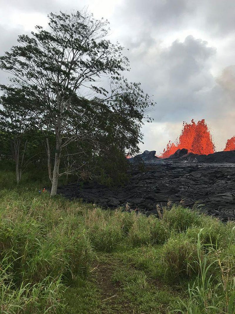
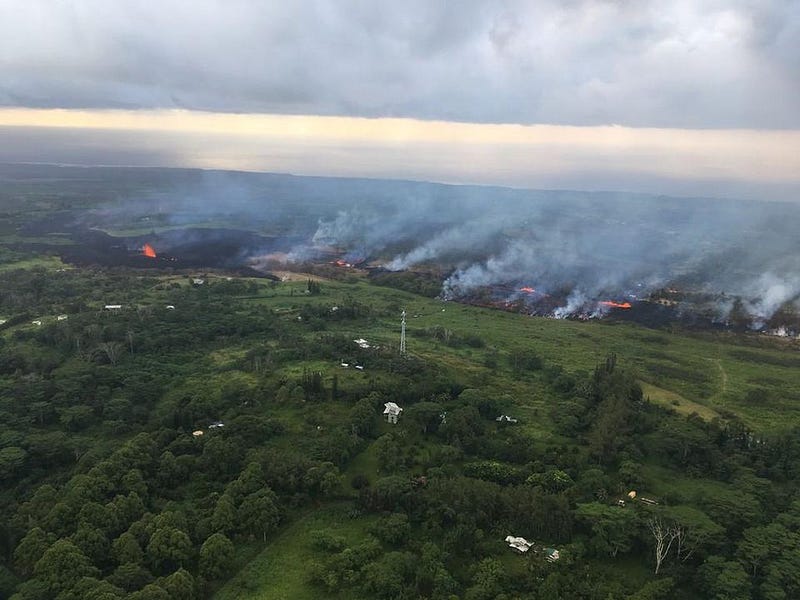
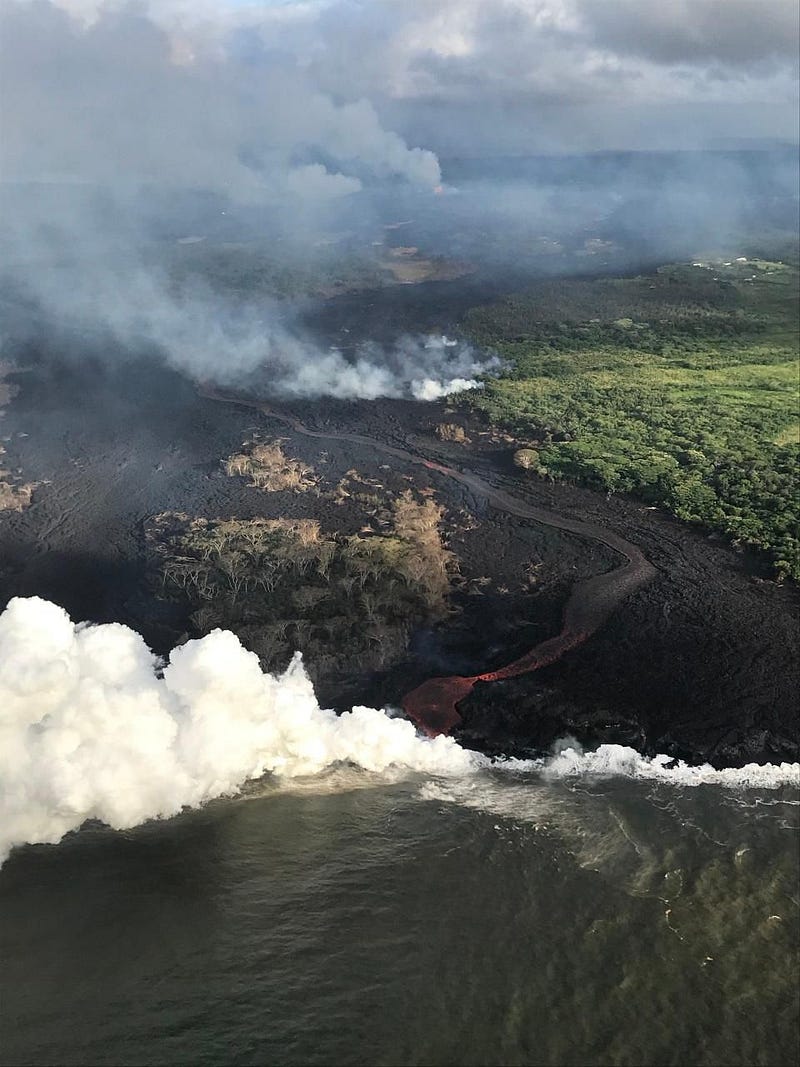
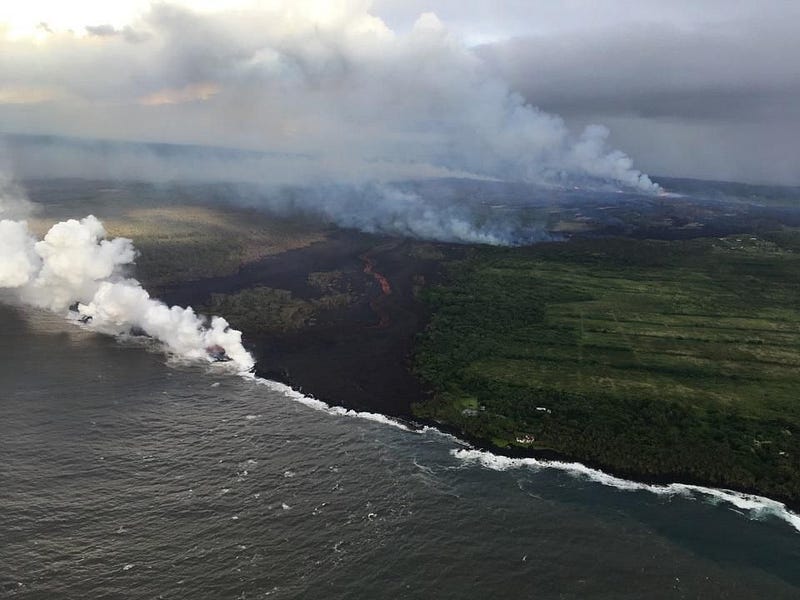
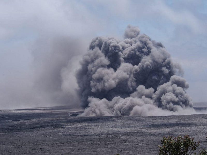
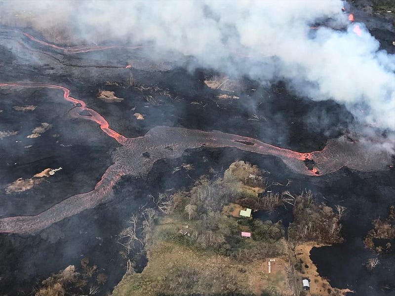
During the current, month, however, the danger has escalated rapidly. Thousands of residents have been evacuated from the southern and eastern portions of the Big Island. Dozens of homes have been destroyed. There are more than 20 fissures that have been created, and new ones threaten to open on a daily basis. Volcanic ash has been hurled, by explosive eruptions, more than 30,000 feet in the air, settling into various populated portions of the island. And as the lava flows into the oceans, new hazards arise still. The danger is ongoing, life-threatening, and unpredictable. But scientifically, just because we don’t know everything about it, doesn’t mean we can’t say a number of incredibly informative things about what’s going on there.
Especially if you or your loved ones are in the vicinity of Hawaii, it’s so important to stay updated, in an accurate fashion, on all the activity occurring over there. And for that, the USGS’s Hawaiian Volcano Observatory is far and away the best place to go for exactly that. The observatory itself was formed in 1912, and was taken over by the United States Geological Survey in 1924, who has run it ever since. Earthquakes, hazardous emissions (like sulphur, ash, and the volcanic pollution known as vog), fissures and eruptions are monitored from several sites, including seismic stations, continuous webcams, and even helicopters.
The information gathered by HVO, most importantly, instantly goes out, worldwide, across the internet. It’s accessible to anyone who knows where to look for it. So where should you go, if you want more information? Here are my top recommendations:
1.) The status of Kilauea volcano. This page offers status updates, every few hours at the present, on the current volcano alert level, the current aviation color code, and updates on what’s happening in various regions of interest. Is there lava erupting? Ground cracking? Where are the most active fissures, and which populated areas are experiencing the most damage? What’s going on with volcanic gas emissions? And is lava still entering the ocean, and is it causing explosions? They have continuous updates about what’s happening in a number of rift zones, on the volcano summit, and where the winds are blowing any ash that may be emitted. If you’re only going to visit one page, this is it.
2.) The Vog information dashboard. Like breathing? I bet you do! The word “Vog” is a portmanteau of volcano, smog, and fog, and results from sulfur dioxide and other volcanic gas emissions that create a smog-like haze that can cause significant damage to any living creature that needs to respirate, including plants and animals. The Vog information dashboard has links to:
- real-time air quality data,
- ash hazards at the summit,
- Vog and wind forecasts,
- hazards and assessments of the lower east rift zone eruption, and
- how to protect yourself from Vog.
The website also does a solid job of telling you where not to be concerned. Not all of the Hawaiian islands, including not all of the Big Island, are significantly affected by this ongoing event!
3.) Protect yourself from volcanic ash. The International Volcanic Health Hazard Network (IVHHN), of which the HVO and the USGS are partners, have the most up-to-date recommendations about keeping yourself and your loved ones safe in the event of volcanic ashfall in your area. This includes how to best prepare for ashfall, what the potential health impacts of volcanic ash are, how to protect yourself (including with respirator masks) from breathing volcanic ash, and advice for communities that are affected by ongoing ashfall events. If you are presently in, or are potentially going to be in, an affected area, this is a resource you absolutely cannot miss.
4.) Multimedia galleries. It’s one thing to hear about or read about what’s happening, but it’s quite another to see it. Delivered in real-time and usually updated multiple times a day, the HVO has a series of multimedia galleries that show you, firsthand, what’s actually happening with the Kilauea eruption. There are photo and video chronologies, which showcase lava flows, eruptions, and what’s occurring at various fissures, including captions and descriptions of events, and accompanied with timestamps.
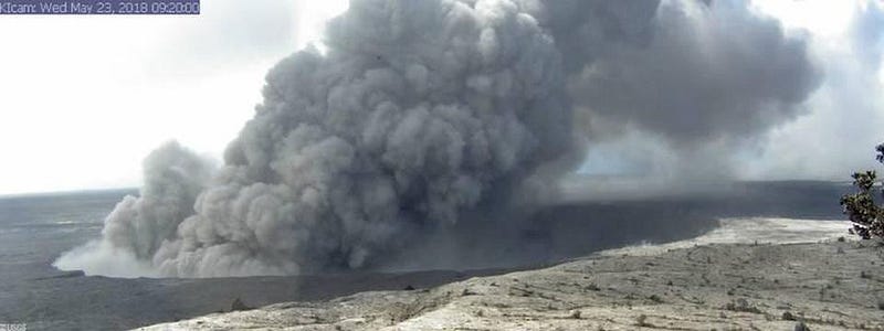
There are webcams from a number of observing locations, showcasing views from the Summit and the East Rift Zone. From the webcams alone, you can see volcanic vents and the ash-and-Vog emissions coming from them. You can get a view of the Kilauea Caldera, and a view in all four cardinal directions of Pu’u ‘Ō’ō and its flanks. Pu’u ‘Ō’ō crater can be seen as well, in both visible light and in infrared (thermal) imaging, the latter of which can see through any volcanic gases. Finally, they show views of lava flows and the rift zones in general. The webcams are operational 24/7, and will even record and display the dark of night if there are no visible signs.
There are also video feeds, updated (on average) once or twice daily, that provide some incomparable views of and recommendations on how to deal with what’s occurring. Even though there are more famous observatories on Hawaii taking videos, the USGS/HVO’s videos are uniquely informative compared to any others.
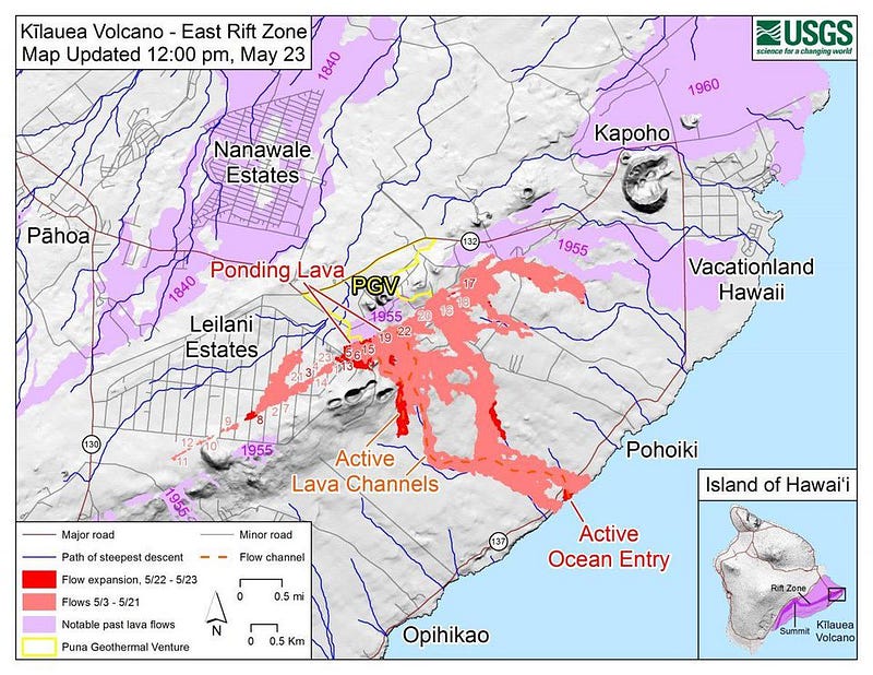
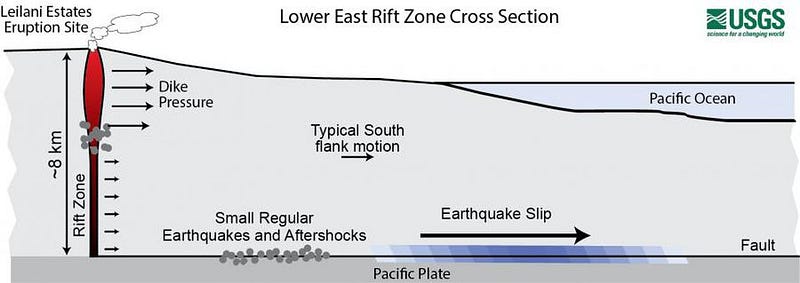
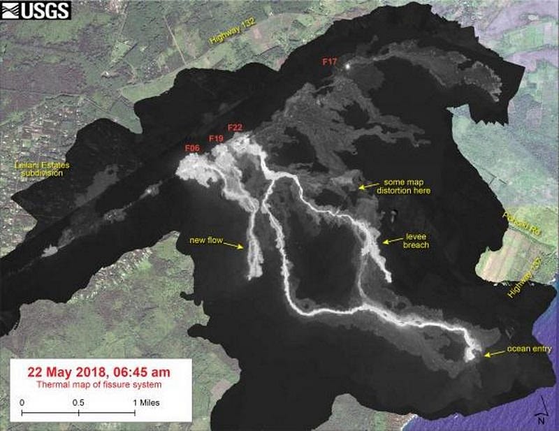
5.) Maps of what’s happening and where. This is perhaps the greatest resource for determining what’s occurring and where. They show fissures and flows, including present, recent, and past lava flows. They display thermal maps of the fissure system and the lava flows that have occurred, overlaid atop satellite imagery. Occasionally, they have radar images that show how things like the eruptive vent at the summit has changed over the past few weeks. Most importantly, they have updated flow fronts, lava pools, lava channels, and ocean entry points. This way, you can know not only where the lava is at any moment, but where the lava flows are headed, and how that’s changed over time.
If you want to stay safe and informed, there are no better resources than what the USGS’s Hawaiian Volcano Observatory provides. The current outburst of volcanic activity may not be the most geologically catastrophic thing to ever happen on the Big Island of Hawai’i, but there are more people living there than ever before. Had there been no monitoring or early warning system, it’s likely that this month would have marked the deadliest volcanic event in the island’s, and America’s, history. Instead, the damage to the people who live there has been absolutely minimized, and we have the Hawaiian Volcano Observatory to thank.
Ethan Siegel is the author of Beyond the Galaxy and Treknology. You can pre-order his third book, currently in development: the Encyclopaedia Cosmologica.