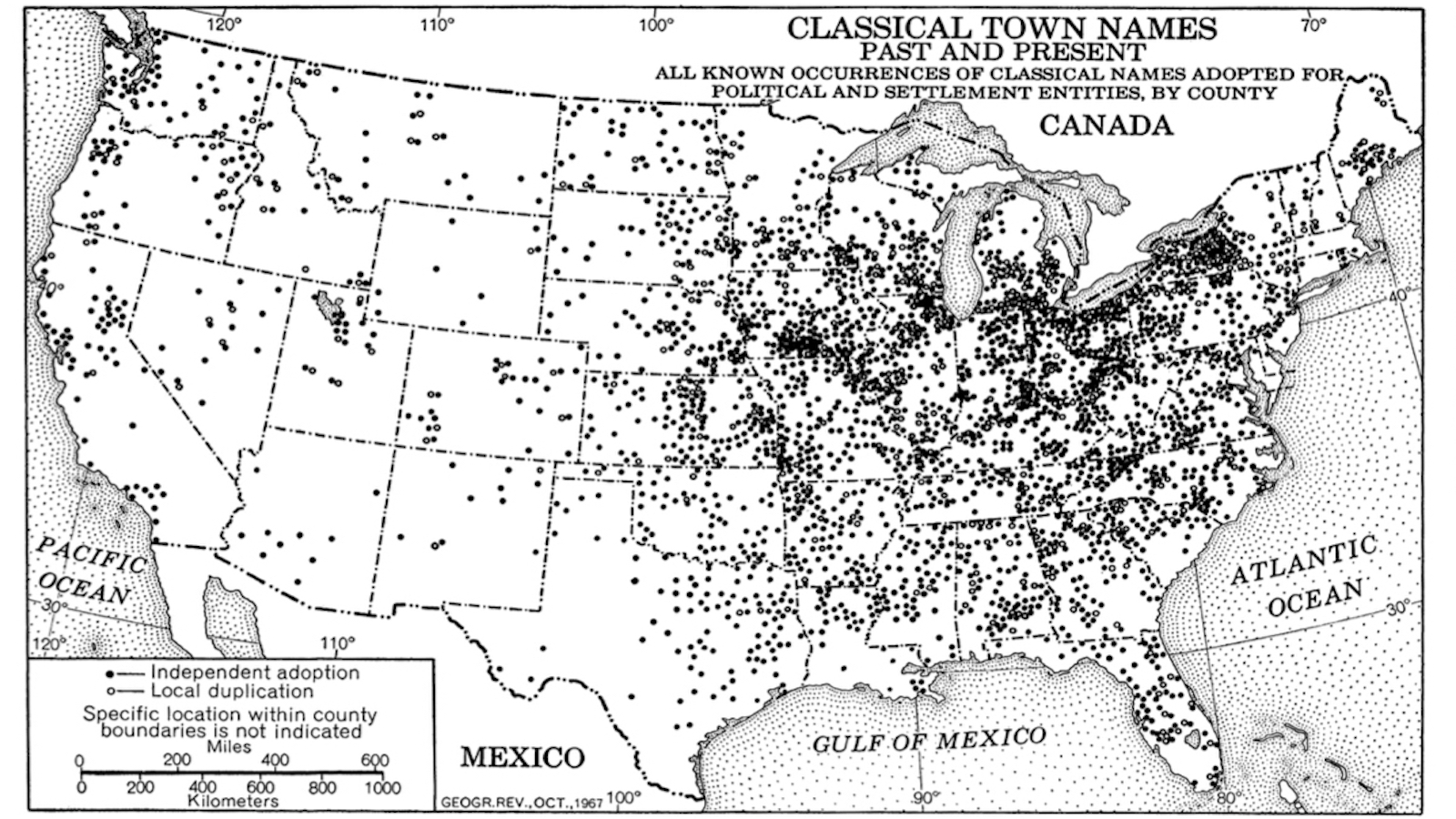
Ohio’s Circleville ditched the grid system. Then it got squared.

- “Squaring the circle” is mathematically impossible, yet it happened in 1850s Ohio.
- Well, sort of. The city of Circleville got rid of its circular grid and replaced it with a rectangular one.
- There’s more weirdness in the small Columbus suburb, including a well-respected family with a decidedly unfortunate surname.
When you’re “squaring the circle,” you’re attempting the impossible. Yet in the mid-19th century, that’s just what the good citizens of Circleville, Ohio, did: They straightened out the circular grid on which their city had been laid out a few decades earlier.
Mathematically impossible
So why didn’t they change its name to Squareville? Perhaps because, similar to its curious origins, strange things keep happening in and to this small town 25 miles south of Columbus.
But first: What is “squaring the circle” and why can’t you do it?
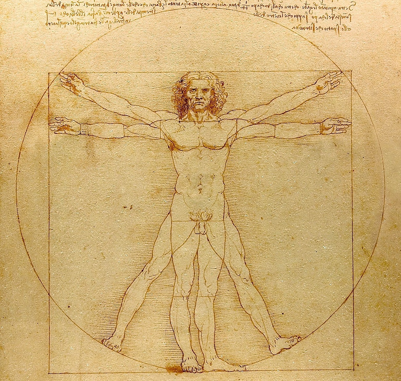
This mathematical conundrum with philosophical implications had been bugging thinkers as far back as ancient Greece. Simply put, the question is: Can you construct a circle that has the exact same area as a square, using only a ruler and compass?
That problem, which informed Leonardo da Vinci’s famous drawing of the Vitruvian Man, was only solved in 1882 when German mathematician Ferdinand von Lindemann proved that π (pi) is a transcendental number. Not only does that mean it’s mathematically impossible to square a circle, but it also proves that there are firm boundaries to human knowledge.
Enigmatic civilization
Circleville’s peculiar layout sprang from an antique mystery of another kind: a Hopewell mound. Giant earthwork mounds are the most spectacular, and almost the only, remains of the enigmatic Hopewell civilization, a network of Native American cultures that flourished throughout the northeastern and midwestern U.S. from around 100 BCE to 500 CE.
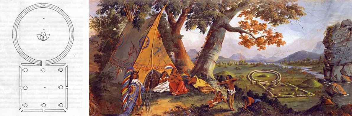
Fast forward to 1810, when Pennsylvania native Daniel Dreisbach was commissioned to establish a county seat for Pickaway County in Ohio, and picked such a mound as the center of the new town. Overgrown but prominent, the nameless monument to a vanished civilization was encircled by two parallel walls of earth. It stood at the intersection of five trails, so it was clearly still important to the indigenous people of that time.
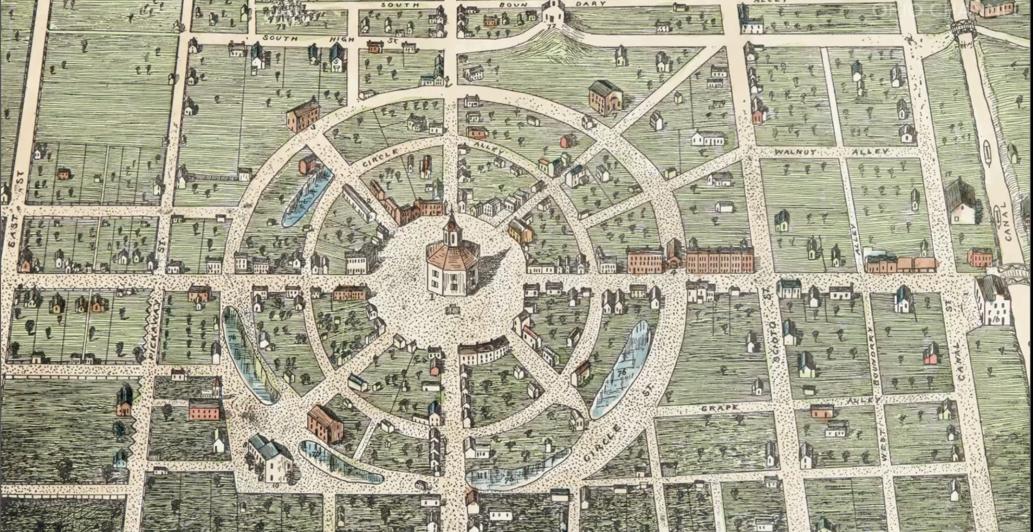
Dreisbach’s plan mimicked the ancient plan: An octagonal courthouse was built on the mound, which became the midpoint for two concentric streets that were connected by straight streets radiating from the center. With such an extraordinary grid, the choice for the new town’s name had a certain inevitability.
“Total obliteration”
But why did Circleville break so radically with that staple of city planning: the gridiron plan? That near-universal mold for North American cities and towns has some pedigree: The Romans loved the grid as a tried and trusted method to lay out insta-cities.
Circle-shaped cities, with roads radiating from the center as they did in Circleville, are rarer, but they weren’t new either. Two famous examples: the Round City of Baghdad, built by the Abassids in the 8th century AD, and Palmanova, founded by the Venetians in 1593 as a star-shaped fortress.
Dreisbach and his team didn’t aim to imitate these grand examples. They just went with what prehistory provided, as the Circleville Union-Herald reminisced on 2 August 1878: “No doubt (they) thought they were doing that which would serve to preserve the ancient monuments from demolition and ruin, and that, with town located here, they would surround them with an interest which would protect and care for them.”
It didn’t work out that way, the paper eloquently laments: “As to the wisdom of their predictions, the total obliteration of every trace of the old forts gives sad witness.”
An immense cheese
Back in the beginning, everybody loved the unusual city plan. On the first sale day, Dreisbach threw a well-attended party, with “an immense cheese (manufactured) for the occasion, weighing several hundred pounds, which was drawn to the barbecue on a large sled.” Dreisbach sold 29 lots that day for a total of $2,276.50 (about $57,500 in today’s money).
However, the novelty attraction of Circleville’s circularity soon wore off. By the 1830s, it was denounced as “childish sentimentality.” But the real objection was practical rather than emotional: It was proving difficult to sell some of the more strangely shaped lots because they were impractical to build houses or other structures on. The city was stuck with large tracts of leftover land.
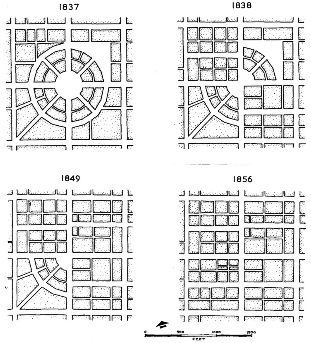
In 1837, concerned citizens united in the Squaring Circleville Company and petitioned Ohio’s General Assembly to have their town “straightened out.” The permission was granted, and in a rather cruel twist of fate, it fell to the very same Daniel Dreisbach to start leveling the town center that he himself had laid out a few decades earlier. Having made the circle, he was now in charge of squaring it. History doesn’t record how he felt about destroying his original work.
Four quadrants
The changes were carried out in four stages: the southeast quadrant was realigned in March 1839 and the northwest one was in September of that same year. The work remained half-finished until 1849, when the northeast quarter was squared, and was completed only in 1856 when the southeast was redone. Whole streets had to be demolished and realigned, buildings torn down or moved. Some call it the earliest example of urban redevelopment in the United States.
That redevelopment also entailed the destruction of almost all of the Hopewell earthworks that had given Circleville its peculiar shape. Dreisbach did not see the final result. He died on the job, still the town’s director, in 1850.
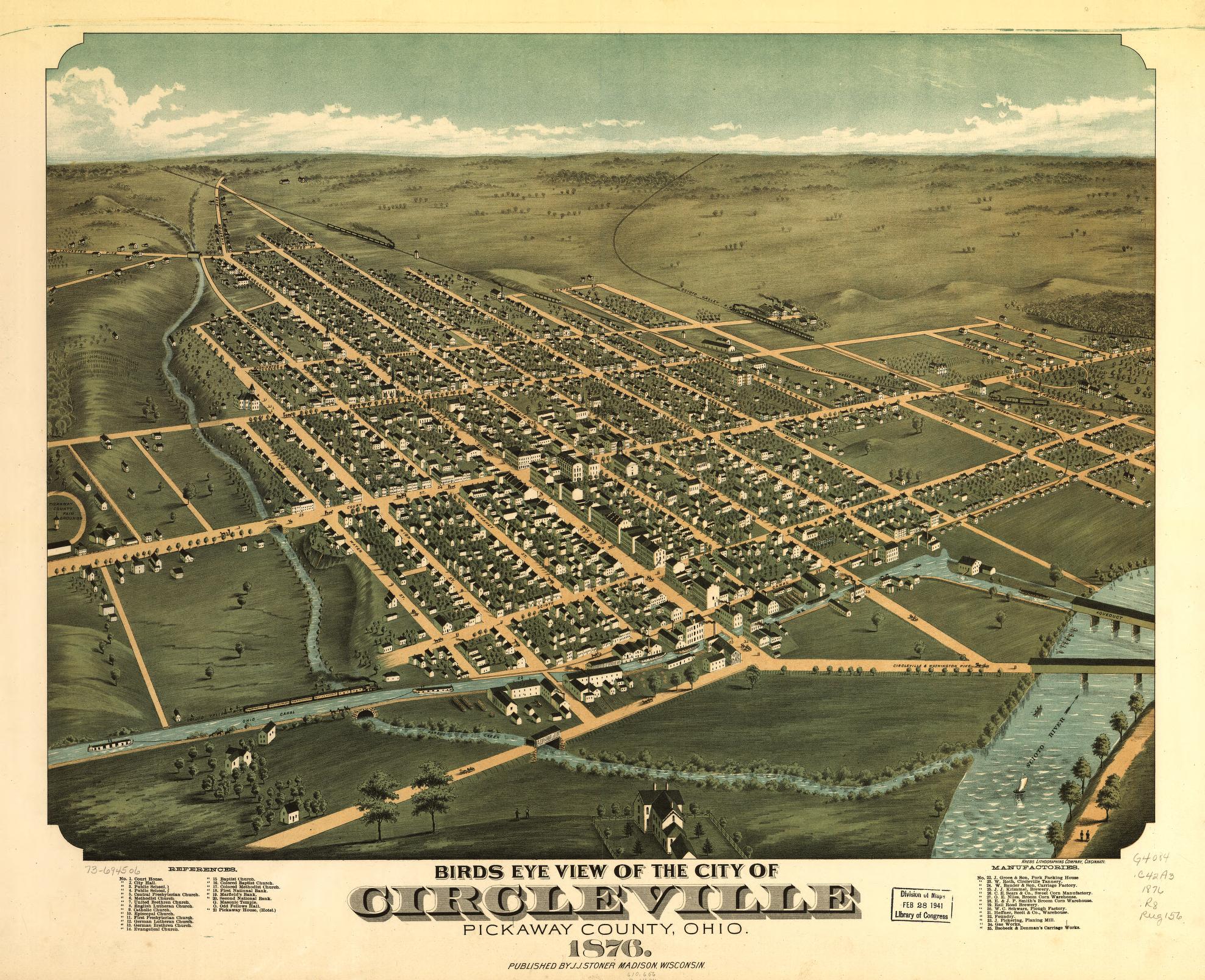
Except for the city’s name (and its nickname, Roundtown), almost nothing survives from Circleville’s circular beginnings, except the Ted Lewis Museum. The building itself, honoring a locally-born jazz band leader popular in the 1920s and 1930s, is perfectly rectangular, but the backyard lot is shaped like a thin slice of pie: a lonely vestige of the town’s early days.
Pumpkin Show
That circular history, and that museum, are not all Circleville has got going for itself, by the way. Circleville is home to America’s largest annual pumpkin festival, also known as “the greatest free show in the world,” visited annually by thousands. At the 116th Circleville Pumpkin Show in October 2023, a giant pumpkin (named Mathilda by its growers, Bob and Jo Liggett) broke the state record, weighing in at 2,388.5 pounds.
Those of a more lugubrious bent will be interested in the Circleville Bombing in 1967, which cost five lives, and the Circleville Writer, an anonymous pamphleteer who terrorized the city from 1977 to 1994.
To end on a lighter note, there’s the story of the Circleville Hitlers. The city boasts not one but two Hitler Roads, and, where #1 and #2 converge, a Hitler-Ludwig Cemetery. There’s a Martha Hitler Park (home the Flying Eagles Disk Golf Course), a Huber-Hitler Road, and, across the Scioto River from Westfall, a small, finger-shaped Hitler Pond.
Arriving in the late 18th century, the Hitlers were among the first European settlers in Pickaway County. George Hitler was one of the first inhabitants of Circleville. He and his descendants were “fine, upstanding citizens,” according to the local paper. They donated land to a cemetery, a park, and a school (Hitler School closed in 1920). Notable family members include George Washington Hitler and his son, Dr. Gay Hitler, who died in 1948, having served his community for 40 years as a dentist.
Strange Maps #1236
Got a strange map? Let me know at strangemaps@gmail.com.
Follow Strange Maps on X and Facebook.
