What an Independent Catalonia Would Do to the Map of Spain
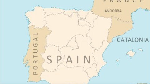
This is what the map of the Iberian peninsula may look like if Spain‘s semi-autonomous region of Catalonia (Catalunya) were to become independent. The peninsula is shared by three instead of two countries. The Pyrenees (1) no longer neatly double as Spain‘s natural northern border.
That third country, taking up the northeastern part of the peninsula, is Catalonia. Despite objections and obstructions by the Spanish government (and perhaps partly because of it), That autonomous region held an independence referendum on October 1st, almost 92% of the votes went to the “Yes” camp.
In a rare direct intervention, the Spanish king Felipe VI strongly denounced the move towards Catalan independence as disloyal to the unity of the Spanish state and an affront to the Spanish government. The Spanish senate also approved direct Spanish rule over the region. The move effectively prevented any consideration of an officialconstitutional court to adjudicate the matter.
Undaunted, Catalonia‘s PresidentCarles Puigdemont said, from his government headquarters in Barcelona, the ratified results of the referendum would be used to effectively declare independence “at the end of this week or the beginning of next”. Francisco Franco, a military general who ruled over Spain and actively oppressed Catalan culture, still lives in the minds of Catalans. Catalonia‘s executivegovernment, headquartered in Barcelona, is known as the “generalitat“— a Catalan world. Its parliament is also located in Barcelona.

For its part, Spain‘s central government in Madrid has threatened to revoke Catalonia‘s current autonomous status if the separatists in Barcelona continue with their ‘conscious decoupling’. Catalonia has called on the EU to mediate via its Brussels headquarters. That would be a de facto recognition of Catalonia‘s separate status on the global stage. For precisely that reason, the EU is unlikely to get involved, leaving the Catalan parliament and the Spanish government to face off. For its part, the United States has publicly sided with the central Spanish government.
So are Madrid and Barcelona headed for a Yugoslav scenario? Perhaps, but then the question is which one. The disintegration of Yugoslavia is remembered mostly through the prism of the horrible, protracted Bosnian war, but the first country to skip the club was Slovenia, the northernmost, wealthiest and ethnically most homogenous of the Yugoslav republics. It did so in the Ten-Days War of 1991, which claimed the lives of less than 70 combatants.
Bloody or not, if Catalonia gets its independence and direct rule, it will be the most dramatic change in Spain‘s cartographic persona since the completion of the Reconquista in 1492 (2). After the defeat and absorption of Granada, the last Muslim kingdom on the peninsula, and with both the independence of Portugal and the northern natural border firmly established, the idea of Spain has become synonymous with its current geographic extension. A Catalan republic would have historical and global implications.

From a Spanish point of view, the new map is depressing. Nothing says “late great nation” like a new map of your country with its former territory reduced. Just imagine a map of the U.S. from which Texas and/or California (and/or Vermont) has vanished. This cartographic slight to Spanish pride may at least partially explain Madrid‘s frankly counterproductive inflexibility towards recent Catalan manoeuvres.
The Catalan perspective, of course, is the diametrical opposite. Catalonia is the wealthiest region in Spain (in 2014 GDP, even edging out Madrid, and way ahead of all other regions). Its economy on its own is greater than than of each country marked red on this map. The region also suffered under the rule of military general Francisco Franco, who privileged Spanish heritage over Catalan culture, forbidding the Catalan language from being taught in public schools.

Larger not just than that of all those micronations (those red dots) or tiny Iceland and nearby Portugal, but also of virtually all countries in Eastern Europe – from the Baltics all the way down to Greece, with the inclusion of countries with much larger populations and resources, such as Romania and Ukraine. Poland, which has 38 million inhabitants to Catalonia‘s 7.5 million, is the only exception.
Will Catalan independence be a success story? Which Catalan leader would carry the region to independence? Its economy will probably have to stomach a setback, as trade will suffer under Spanish anger and European uncertainty on what to do with the first successful separatist movement within the EU. Similar economic concerns prevented Scotland from achieving independence from the EU in its latest referendum for direct rule.

But there’s a large internal problem too with Catalonia‘s independence movement. The result of the recent referendum may have been overwhelmingly pro independence, that’s because the turnout was relatively low, at just 42%. The actual divide is much closer to fifty-fifty: a July poll put the “Yes” camp at 41% and the “No” camp at 49%.
This map is an interesting, although imperfect, gauge of the relative strength of Catalan national feeling. It shows the percentage of Catalan speakers in each of Catalonia‘s regions, and that paints a more fragmented picture than the overwhelming majority of the referendum. The independence movement is passionate but not exactly united, at least not geographically.

The share of Catalan speakers in Catalonia is lowest in Metropolita, the region which includes the capital Barcelona: here, just over a quarter of the inhabitants speak Catalan. The highest share, almost three quarter, is achieved in the southern Terres de l’Ebre region. The two regions in between both have scores in the mid-30s. The Comarques Gironnes, between Barcelona and France, manage just over 50%. The three inland regions have more comfortable majorities, of just over 60%.
—
Strange Maps #861
All maps from @OnlMaps. To see three thousand years of Spanish (and Portuguese) borders evolve and change in just 3:55, click here. Even when independent, Catalonia will never be able to get rid of Spain: see #793.
Got a strange map? Let me know at strangemaps@gmail.com.
(1) Greek myths say the mountain chain was named after Pyrene, daughter of Bebrix, a Gallic king visited by Hercules. The Greek hero got drunk and raped Pyrene, who later gave birth to a snake. Afraid of her father’s anger, she ran into the woods, shouting out her story to the trees. This attracted the attention of wild animals, who tore her to pieces. Sober again, Hercules finds her remains and laments his crime, burying Pyrene. When he shouts out her name, the mountaintops echo it back to him. The land has remembered her name ever since.
(2) The two main exceptions: when Spain and Portugal were united (1580-1640) and Catalonia was annexed by France (1812-14). Minor ones include the British annexations of Menorca (twice, but impermanent) and Gibraltar (ongoing).
