One mission is now the make-or-break future for NASA Earth science

With the launch of JPSS-1 coming up this year, everything that NASA Earth science stands for hinges on its success.
“There is, then, no water that is wholly of the Pacific, or wholly of the Atlantic, or of the Indian or the Antarctic. The surf that we find exhilarating at Virginia Beach or at La Jolla today may have lapped at the base of antarctic icebergs or sparkled in the Mediterranean sun, years ago, before it moved through dark and unseen waterways to the place we find it now. It is by the deep, hidden currents that the oceans are made one.” –Rachel Carson
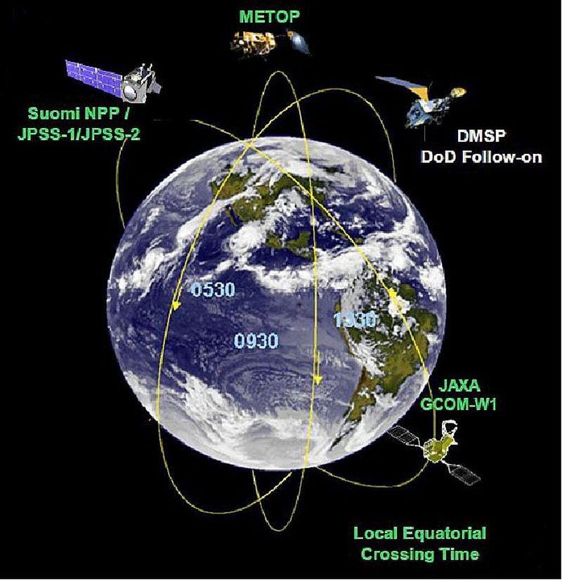
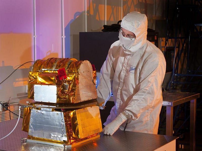
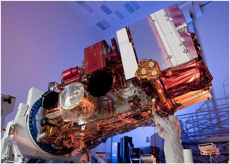
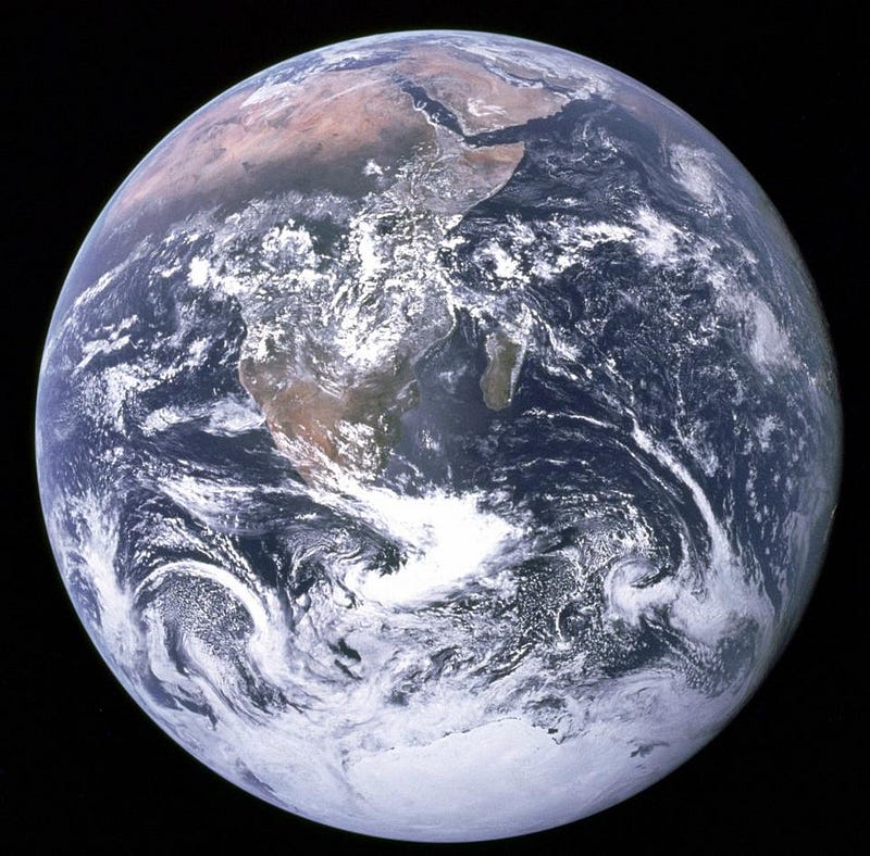
When it comes to viewing anything in space that changes — whether it’s a distant galaxy, star, or even the Sun or Earth in our own backyard — the goal is to measure it as frequently and comprehensively as possible. For the Earth, that means imaging the planet at high resolution, with as many instruments as we can, covering the entire globe in as little time as possible, while in close orbit around our planet. The greatest Earth-monitoring satellite of all time, the Joint Polar Satellite System (JPSS-1), is scheduled to launch in just a few months, and will give us climate and weather modeling data that’s leaps and bounds better than anything we’ve ever had. It also has to last until the United States comes to our scientific senses, because with a suite of cancelled Earth observing missions and JPSS-2 in funding jeopardy, it’s our only hope for obtaining this type of quality data for the foreseeable future.
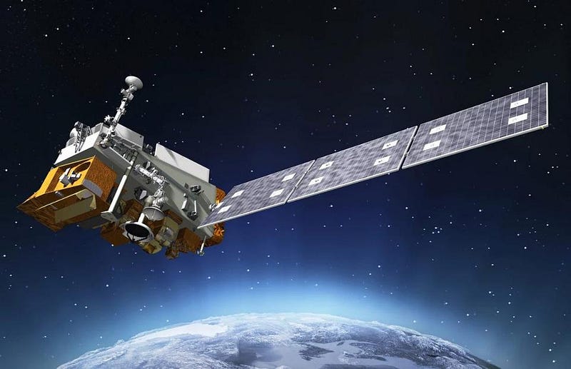
For a single satellite, you couldn’t ask for more than the design of JPSS. As far as covering the world at high-resolution, its plan really does deliver the best of all worlds. By choosing a low-Earth polar orbit, it gets us all of the following:
- it orbits then Earth very quickly: completing a revolution once every 101 minutes,
- it’s close enough, at 824 km above the surface, to take incredibly high-resolution imagery,
- it contains five separate, independent instruments, each probing various weather and climate phenomena,
- and due to its wide field-of-view and flight plan, is capable of obtaining full-planet coverage every 12 hours.
That means, twice a day, it can obtain global coverage of weather and climate phenomenon, hitting every single location on planet Earth.
This is vital to protecting the Earth, in terms of human preparing for and mitigation of the damage that natural disasters can have. The type of data that JPSS-1 will take can be essential to extreme weather prediction and in early warning systems. Had this satellite existed some twelve years ago, it could have severely mitigated the impact of a natural disaster like Hurricane Katrina. To accomplish this feat, i.e., to know what’s coming even in the face of a chaotic system, JPSS is equipped with five instruments on board, each of which is fundamentally different and complementary to one another.
1.) The Cross-track Infrared Sounder (CrIS) instrument, which will measure the 3D structure of the atmosphere. This includes looking for signatures and the quantitative altitude presence of water vapor and temperature in over 1,000 infrared spectral channels. The information obtained by the CrIS instrument is vital for making accurate weather forecasts up to seven days in advance of both major and mundane weather events. If you at all value long-range accuracy in your weather forecasts, the CrIS instrument is indispensable, and meteorologists worldwide are poised to take advantage of this information.
2.) The Advanced Technology Microwave Sounder (ATMS), which an even more advanced thermal imager of atmospheric layers than CrIS is. By adding 22 microwave channels to atmospheric measurements, they improve temperature and moisture readings down to 1 Kelvin accuracy for all of the different layers separable within the troposphere. For scientists interested in testing some of the major predictions of the theory of human-caused global warming, detailed measurements of the tropospheric temperatures over long timescales is one of the greatest improvements we could ask for.

3.) The Visible Infrared Imaging Radiometer Suite (VIIRS) instrument is perhaps the most powerful imager on board the satellite. It was designed to take visible and infrared pictures at a resolution of just 400 meters (1312 feet), enabling us to track not just weather patterns but the behaviors and beginnings of wildfires, the evolution of sea temperatures, the amount and effects of nighttime light pollution, and algal blooms and other changes in ocean-color observations. If there’s a change in the Earth’s surface on scales of 400 meters (a quarter of a mile) or more, VIIRS will be able to detect it.
4.) The Ozone Mapping and Profiler Suite (OMPS) is capable of measuring how the ozone concentration varies with altitude and in time over every location on Earth’s surface. You might think the primary use would be to measure the changes in ozone concentrations and the long-term effects of the healing of the hole in the ozone layer, but OMPS goes way beyond that. Ozone is perhaps the chief atmospheric component in preventing the Sun’s ultraviolet radiation in penetrating down to the Earth’s surface. By measuring the ozone concentrations, we can measure how effectively the atmosphere absorbs and transmits the most dangerous form of radiation that the Sun routinely emits.
5.) And finally, there’s the Clouds and the Earth’s Radiant System (CERES), which will help quantify the effect of clouds on Earth’s energy balance. Clouds both reflect sunlight and trap the heat re-emitted by the Earth’s surface, with different types, altitudes, and classes of clouds having differing effects. The uncertainty that presently exists in the relationship between clouds and the rate and efficiency of radiation absorption/emission is one of the largest uncertainties in climate modeling today, and CERES will improve that tremendously.
The joint partnership between NASA and NOAA has been designed to cover the next 20+ years: through 2038, where a series of four JPSS satellites will keep continuous monitoring over the Earth. The JPSS program promises to not only provide early and detailed warnings for disasters like hurricanes, volcanoes and storms, but for longer-term effects like droughts and climate changes. Emergency responders, airline pilots, cargo ships, farmers and coastal residents all rely on NOAA and the National Weather Service for informative short-and-long-term data. The JPSS constellation of satellites will extend and enhance exactly these monitoring capabilities far into the future. This will be the greatest set of meteorological tools ever available to humankind, but it relies on the continued development and launch of subsequent JPSS satellites, at an interval of approximately one every five years. These are expected to last approximately seven years apiece, so a continued investment is necessary, if we care about accurate weather and climate monitoring.
Observing the Earth, mitigating disasters, predicting the weather, and learning how the world we all inhabit is behaving shouldn’t be a partisan issue. Yet, the cuts being made to NASA Earth Science and NOAA — the two organizations partnering to make the JPSS program a success — threaten not only future satellites, but humanity’s ability to collect and use the data coming from those satellites. If something catastrophic happens this year, like a launch failure, there is no backup satellite. And if we fail to invest in the planned JPSS-2 and beyond, we’ll find ourselves in the worst possible situation of all: where our very ability to predict and monitor the behavior of our own planet crumbles away. The science tells us how to know so much about our world, but without investing in the technology to collect the data and the people to analyze and distribute it, we’ll fall back into ignorance, even as the stakes for succumbing to the effects of a natural or man-made disaster are higher than ever.
Ethan Siegel is the author of Beyond the Galaxy and Treknology. You can pre-order his third book, currently in development: the Encyclopaedia Cosmologica.