Skip to content
Strange Maps

15 – Divided States of America

Sign up for Smart Faster newsletter
The most counterintuitive, surprising, and impactful new stories delivered to your inbox every Thursday.

I was alerted to these maps by a Turkish gentleman, who posts them on his website. They are a reaction to the map of the Middle East, re-drawn as it was in the July issue of the US Armed Forces Journal(mentioned earlier in this blog). This American vision has upset a lot of people in the Middle East, not in the least in Turkey, which, in that American scenario, would lose about a quarter of its current territory in the East to a Free Kurdistan.


Unfortunately, my Turkish is not very good, so I can’t read the text explaining the map-drawing competition. The caption above the maps is, however, clear: Divided States of America in, United States of America out. Some maps are funny, others are a bit grim, but every map speaks volumes about the ‘hearts and minds’ the current US administration has lost, around the world and particularly in the Middle East.

Here is a selection, taken from Açik Kistihbarat‘s site.

(a) Canada comes south
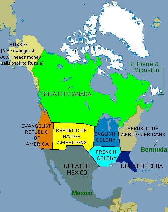
  • Greater Canada eats up a big slice of the US south of the 49th parallel, which presently forms the border between the US and Canada from Washington State to Minnesota.
  • Greater Cuba includes Florida and parts of Georgia and Alabama.
  • The rest of the East Coast states are the Republic of Afro-Americans.
  • The Mid-West is divided between an English Colony in the north and a French Colony in the south – a reference obviously to the Louisiana Territory, which was a lot bigger than the present state of the same name, and French until 1803.
  • Greater Mexico has reclaimed some of the territory lost after the Mexican-American War of 1846-1848, including Texas, the original cause of the war when the Mexican ‘rebel province’ was annexed by the US.
  • The West Coast states form an Evangelist Republic of America, which has re-sold Alaska to Russia.
  • The rump of the US is a Republic of Native Americans.
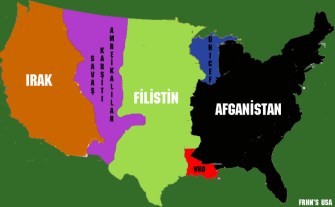
  • (b) Afghano-America

    The three countries most affected by American foreign policy get a big slice of the US, Iraq occupying the West Coast, Afghanistan the eastern part up to the Mississippi, Palestine most of what’s in between. A purple sliver between Iraq and Palestine is reserved for something I can’t translate. Bizarrely, two UN institutions get Louisiana (WHO) and Wisconsin and some of Michigan (Unicef).

    Sign up for Smart Faster newsletter
    The most counterintuitive, surprising, and impactful new stories delivered to your inbox every Thursday.

    Related

    Up Next
    Cornwall is the southwesternmost county of England. As with other ‘extremities’ of the British Isles, it was one of the refuges of the original (partially romanized) Celtic inhabitants, fleeing before […]