Skip to content
Strange Maps

The U.S., Drawn from Memory

United Shapes of America
Sign up for the Smarter Faster newsletter
A weekly newsletter featuring the biggest ideas from the smartest people

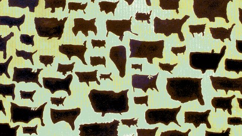
This canvas by artist Kim Dingle doesn’t look like a map, more like a herd of cows. But actually it’s a collection of maps. The artist asked teen-aged school kids in Las Vegas to draw their country in the shape they thought it had. 


  • Florida is represented in some way on more or less every map, the protrusions of Texas and New England are less common. Probably because Florida’s is a physical limit to the US, while the borders of Texas and New England are political (and don’t show up on a satellite map, for instance).
  • The indentation in the US’s northern border made by the Great Lakes is missing in almost all drawings.
  • So are Alaska and Hawaii – but maybe the kids were only asked to draw the 48 contiguous states.
  • Many do manage to get Texas‘s southern protrusion, but some also add an extension in the west, which in all probability is the peninsula of Baja California – Mexican and therefore non-US, but unmissable on any map as it’s a huge geographic feature.
  • A few manage to get the bulging of the US West Coast, but many draw a straight line there; in fact, a lot of these drawings resemble not much more than box-shapes.
  • Strange Maps #61

    Got a strange map? Let me know at strangemaps@gmail.com.

    Sign up for the Smarter Faster newsletter
    A weekly newsletter featuring the biggest ideas from the smartest people

    Related

    Up Next