The Free and Independent Republic of West Florida

“West Floriday, that lovely nation,
Free from king and tyranny,
Thru’ the world shall be respected,
For her true love of Liberty!”
So goes a marching song that never got to mature into a national anthem. Too brief was the independence of a smallish North American state calling itself the Free and Independent Republic of West Florida (the spelling ‘Floriday’ was just for rhyming purposes). This plucky little country was the original ‘Lone Star State’, long before Texas usurped the title (and the star). By then, West Florida had been unceremoniously annexed by the US.
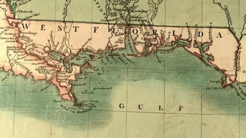
The historical-geographical term West Florida describes a contested region with varying borders on the north shore of the Gulf of Mexico. Sovereignty over the territory was equally fleeting, drifting from French and Spanish to British to Spanish again. The brief spell of self-government gave way to US sovereignty, which apart from the Confederate years continues to this day. Nowadays, unless applied to the western panhandle of the present-day state of Florida, ‘West Florida’ is a term without meaning. The former territory is split up and incorporated into parts of the states of Louisiana, Mississippi, Alabama and Florida.
Until 1763, West Florida was partly Spanish (with a garrison at Pensacola) and partly French (with Mobile an outpost of the French colony of Louisiana). In that year, the treaty concluding the Seven Years’ War awarded to Britain all of Spanish Florida and that part of French Louisiana that lay between the Mississippi and Perdido rivers and north of Lake Pontchartrain. The British reorganised all this new land on the Gulf of Mexico into East Florida (most of present-day Florida) and West Florida, bounded on the west by Lake Pontchartrain and the Mississippi River, on the north by the thirty-first parallel and on the east by the Apalachicola River. British West Florida’s capital was Pensacola.
In 1764, the British extended the northern border of West Florida to 32°28’, encompassing the southern third of present-day Mississippi and Alabama. The 1783 Treaty of Paris, which ended the American War of Independence, saw both British Floridas transferred back to Spain – but without specifying the borders.
Naturally, Spain wanted the border extended to the north in 1764, while the newly independent US insisted on the border at the thirty-first parallel. Spain recognised the former position at the 1795 Treaty of San Lorenzo.
But there was more wrangling over West Florida. France had ceded its gigantic Louisiana Territory to Spain in 1763, but Spain returned it to France in the secret Treaty of San Ildefonso in 1800.
Three years later, the US bought that giant territory from France in what became known as the Louisiana Purchase. The US claimed the territory between the Mississippi and Perdido Rivers, as it had been part of French Louisiana prior to 1763. Spain insisted it had not returned that territory to France in 1800 and continued to administer it.
Meanwhile, new American settlers in the territory united with ‘old’ settlers from the British era to resist Spanish rule, leading to a rebellion in 1810. On September 23, 75 West Floridian rebels overcame a Spanish garrison of 28 (sleeping) soldiers at Baton Rouge, replacing the Spanish colours with the Bonnie Blue Flag (a single white star on a blue field) of the new nation. The fight left two dead and five wounded – sources aren’t clear whether these were rebels or soldiers. Independence was formally declared three days later – and would last a grand total of 74 days.

The town of St. Francisville was established as the new capital. The nation’s borders were the thirty-first parallel to the north, the Perdido River to the east and the Mississippi River to the west. None of present-day Florida was part of the new republic, whose official name nonetheless was, simply, ‘State of Florida’.
Apparently the West Floridians weren’t so keen on independence as on absorption by the US. Their first and only ‘president’ was Fulwar Skipwith, a former American consul general to France under Jefferson who had successfully negotiated the Louisiana Purchase, and who mentioned in his inaugural address: “(…)the blood which flows in our veins (…) will return (…) to the heart of our parent country.” Previously, he had supported self-rule for West Florida as “the best way to turn the captured province over to the United States.”
Yet on October 27 of 1810, the US annexed the region by a simple proclamation, claiming the territory was part of the original Louisiana Purchase. This did not sit well with the West Floridians themselves, who would have preferred to enter the Union on their own terms. The rebels threatened to rebel again, Governor Skipwith even stated he was ready to “die in defense of the Lone Star Flag” when William C.C. Claiborne, sent by Washington to take possession of the territory, refused to recognise his government. He eventually backed down and accepted American annexation.
The western part of West Florida was attached to Orleans Territory in 1810, the rest, known as the Mobile District to the Mississippi Territory in 1812. Spain continued to dispute the US annexation until it ceded all of (East) Florida to the US in 1819, which was organised into the Florida Territory in 1822.
Today, those parts of Louisiana once part of West Florida are still known as the Florida Parishes. In 1993, the Louisiana State Legislature renamed I-12 through these parishes the ‘Republic of West Florida Parkway’. In 2002, the great-granddaughter of governor Skipwith donated the original copy of the West Floridian Constitution to the Louisiana State Archives. The State of Florida itself incorporates only a small slice of former West Florida.
West Florida maps found here and here.
Strange Maps #84
Got a strange map? Let me know at strangemaps@gmail.com.


