Can you guess the legend to this map?
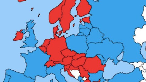
Image: Vivid Maps
- Europe divided into two blocs? That’s not unheard of in history.
- However, this map of Red vs. Blue countries is indecipherable without its legend.
- That key is both trivial and unexpected. Can you guess what it is?

What do Iceland and Greece share that distinguishes them from what France and Poland have in common?
Image: Vivid Maps
Red vs. Blue
What does this map show? Don’t skip ahead. See if you can guess what it’s about. We’d be pretty amazed if you could.
It shows Europe divided into two blocs. That’s not unheard of in history. It’s just that these two are bafflingly unfamiliar. It’s not the EU versus the rest, nor NATO versus the Warsaw Pact. Not Triple Alliance vs. Triple Entente. Neither Napoleonic France and its satellites versus Britain and its allies. Rome vs. barbarians? Nope.
Let’s have a look at who’s actually in these two blocs.
- In red: a contiguous slice of Europe, from up in Norway all the way down to Greece, anchored on Germany – the only one of Europe’s Big Five (1) in the club. However, the red zone also includes outliers such as Iceland and Ireland.
- In blue: everybody else, in two zones separated by the red one. In the south and west, we find the other four members of the Big Five, and some smaller countries. In the east and north, there’s Russia, Turkey and places in between and nearby, including Poland and Ukraine.
These colours denote a difference that is intriguing because you probably never even realised it existed. After this, you won’t be able to ever un-see it.

You may have never noticed, but you can’t un-know it now: red means ‘furthest first’, blue means ‘longest last’.
Image: Vivid Maps
Distance sequencing
- In Red Europe, road signs show city distances from furthest on top to nearest at the bottom. As the example provided shows, if you’re driving north on the E4 in southern Sweden, distant Stockholm (557 km away) is listed first, nearby Åstorp, just 13 km down the road, last.
- In Blue Europe, it’s the other way around: nearest cities on top, furthest ones at the bottom of the sign. On the E40 in Poland, nearby Kraków (58 km) comes before Jędrzychowice, far away on the German border, 465 km to the west.
It’s quite likely you never gave a moment’s thought to the sequencing of distances on road signs. But plenty of traffic experts must have – and as this map shows, they’re divided in two diametrically opposed blocs. In the red one, ‘Furthest is First’; in the blue one, ‘Longest is Last’.Which option is better? That’s an esoteric riddle on par with the question of how many angels can dance on the head of a pin. To any but the most rabid exegetes of road signage, the answer is unimportant and trivial. And that’s precisely why this map is so fascinating. It scratches the surface of the world to reveal a layer of reality slightly outside the realm of the expected – at least to the vast majority of us. The result is a map that is arrestingly unfamiliar. A few other examples come to mind.

Image: Strange Maps
Latin vs. Greek
Some involve mysterious lines on the map that divide the world into two wholly unexpected halves. Take for instance the Jireček Line, which divides the Balkan peninsula into areas of Roman and Greek influence, based on archeological finds (see #128).

Image: Wikimedia Commons
Football vs. rugby
Or the Barassi Line, which cuts across the east of Australia from the Northern Territories to New South Wales, demarcating the part of the country, west and south of the line, where Australian-rules football is more popular, from the part to the line’s east and north, where rugby (league or union) sets more hearts racing.

Image: Demography Resources
The Hajnal Line
And then there’s the Hajnal Line, roughly from St Petersburg to Trieste, that divides Europe into two distinct zones of ‘nuptuality’: west of the line, marriage rates and fertility are comparatively low, even before the 20th century; to the east, both are (or were) comparatively high. Prior to relatively modern times, the late marriage pattern in Western Europe was fairly unique in the world.

Image: Reddit.com/r/MapPorn
The Siktir League
Here’s a map that fortuitously flashed up the screen a few days ago, showing a weird coalition of countries, from the western Balkans all the way to the borders of China.
Alexander the Great’s empire? Not quite. It’s a map of countries where the swear word ‘siktir’ (‘get lost’ or ‘f*ck off’) appears in the native language. Considering that these languages include members of the Romance, Slavic, Turkic families, that’s quite a feat (2).
Do you have any other examples of lines, colours and coalitions on maps that show the world in a different light? Let me know at strangemaps@gmail.com.
Strange Maps #981
(1) The EU may consist of 28 (soon 27) members, but just five countries constitute around 80% of the bloc’s population and GDP: Germany, France, the UK, Spain and Italy.
(2) Croatia may be one country too many included on this map: speakers of that language report never using or hearing the word.
