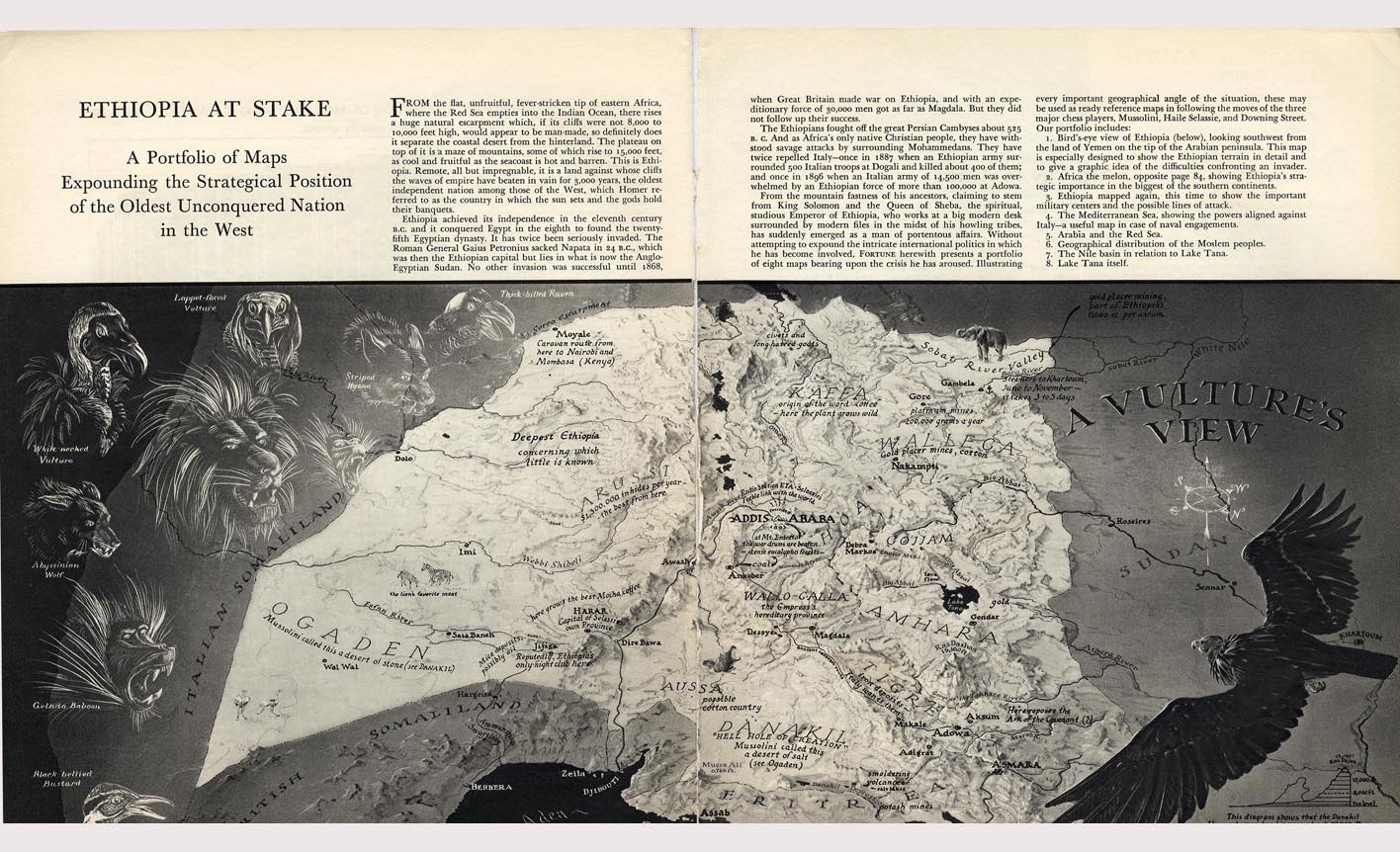
100 – A Vulture’s View of Ethiopia

n
Richard Edes Harrison trained as an architect, but became known as an illustrator for Time (from 1932 onwards) and other national news magazines. His specialty was cartography, applying unusual perspectives and orientations to maps to present information about the global flow of oil, the network of global communications cables or the geographic lay-out of potential battlegrounds (many of his maps were made in the run-up to and during World War Two). Harrison also worked as a cartographic consultant for the US government and lectured at several universities on cartography.
n
Much of Harrison’s best work was done from 1940 onwards for Fortune magazine, where his characteristic signature was the expansion of the bird’s-eye view to worldwide settings. A selection of Harrison’s Fortune-maps was published in 1944 as ‘Look at the World – The Fortune Atlas for World Strategy’. Out of print nowadays, but I managed to find a copy via Amazon.
n
This map’s not in it, though – possibly because by 1944, the Ethiopian conflict as prefigured in this map had already played out. In any case, I can’t find the exact date for this map on the site where I found it. The ‘vulture’s view’ and the intriguing legends (*) give it the appearance of a treasure map. The article accompanying the map, reproduced here, also has a very Indiana Jonesy feel to it.
n
“ETHIOPIA AT STAKE. A Portfolio of Maps Expounding the Strategical Position of the Oldest Unconquered Nation in the West.”
n
“From the flat, unfruitful, fever-stricken tip of eastern Africa, where the Red Sea empties into the Indian Ocean, there rises a huge natural escarpment which, if its cliffs were not 8,000 to 10,000 feet high, would appear to be man-made, so definitely does it separate the coastal desert from the hinterland. The plateau on top of it is a maze of mountains, some of which rise to 25,000 feet, as cool and fruitful as the seacoast is hot and barren. This is Ethiopia. Remote, all but impregnable, it is a land against whose cliffs the waves of empire have beaten in vain for 3,000 years, the oldest independent nation among those of the West, which Homer referred to as the country in which the sun sets and the gods hold their banquets.”
n
“Ethiopia achieved its independence in the eleventh century B.C. and it conquered Egypts in the eighth to found the twenty-fifth Egyptian dynasty. It has twice been seriously invaded. The Roman General Gaius Petronius sacked Napata in 24 B.C., which was then the Ethiopian capital but lies in what is now the Ango-Egyptian Sudan. No other invasion was successful until 1868, when Great Britain made war on Ethiopia, and with an expeditionary force of 30,000 men got as far as Magdala. But they did not follow up on their success.”
n
“The Ethiopians fought off the great Persian Cambyses about 525 B.C. And as Africa’s only native Christian people, they have withstood savage attacks by surrounding Mohammedans. They have twice repelled Italy – once in 1887 when an Ethiopian army surrounded 500 Italian troops at Dogali and killed about 400 of them; and once in 1896, when an Italian army of 14,500 men was overwhelmed by an Ethiopian force of more than 100,000 at Adowa.”
n
“From the mountain fastness of his ancestors, claiming to stem from King Solomon and the Queen of Sheba, the spiritual, studious Emperor of Ethiopia, who works at a big modern desk surrounded by modern files in the midst of his howling tribes, has suddenly emerged as a man of portentous affairs. Without attempting to expound the intricate international politics in which he has become involved, FORTUNE herewith presents a portfolio of eight maps bearing upon the crisis he has aroused. Illustrating every important geographical angle of the situation, these may be used as ready reference maps in following the moves of the three major chess players, Mussolini, Haile Selassie and Downing Street.”
n
“Our portfolio includes:
n1. Bird’s-Eye view of Ethiopia (below), looking southwest from the land of Yemen on the tip of the Arabian peninsula. This map is especially designed to show the Ethiopian terrain in detail and to give a graphic idea of the difficulties confronting an invader.
n2. Africa the melon, opposite page 84, showing Ethiopia’s strategic importance in the biggest of the southern continents.
n3. Ethiopia mapped again, this time to show the important military centers and the possible lines of attack.
n4. The Mediterranean Sea, showing the powers aligned against Italy – a useful map in case of naval engagements.
n5. Arabia and the Red Sea.
n6. Geographical distribution of the Moslem peoples.
n7. The Nile basin in relation to Lake Tana.
n8. Lake Tana itself.”
n
(*) Such as:
n
Deepest Ethiopia – concerning which little is known.
nJijiga – reputedly, Ethiopia’s only night club here.
nKaffa – origin of the word ‘coffee’ – here the plant grows wild.
nRadio Station ETA – Selassie’s feeble link with the world.
nAt Mt. Entoffo (?) the war drums are beaten – dense eucalyptus forests.
nDanakil – “hell hole of creation”.
nTigre – iron deposits – Italy wants them.
n
(and finally, talk about Indiana Jonesy stuff: )
n
Here reposes the Ark of the Covenant.
n

