If the Earth Stood Still, This is What the World Map Would Look Like

What would happen if the earth stood still? If the whole planet became a no-spin zone? Worst case scenario: Keanu Reeves destroys the world (1). Slightly less worse case: the oceans migrate to submerge much of the inhabited world. This global catastrophe would lead to the formation of a single supercontinent straddling the equator.
Far-fetched as such a cataclysm might be, as a thought experiment it allows us to examine the gravitational dynamics of our globe, precariously spinning on its axis like a basketball on the fingertip of a Harlem Globetrotter.
Take, for example, the evident truth that land and ocean meet at sea level. A truth so evident that for once (and only once) metres, miles, yards and kilometres all agree: elevation zero. It would seem equally evident that sea level is the same everywhere. But it isn’t.
For the earth isn’t perfectly round. Spinning distorts its shape into what is called an oblate spheroid – a bit flatter at the poles, slightly bulging at the equator. On the grander scale, this discrepancy seems laughably negligible: it amounts to a mere 0.3% difference in length between polar and equatorial axes. But in terms of man-as-measure-of-all-things, it’s a whopper. Or to be more precise, a half marathon: 21 km (13 mi.)
Now imagine the earth stopping cold in its tracks. No more centrifugal force. No more bulging. Over time, the earth’s shape would approximate a perfect ball. But most of the immediate readjusting would be done by the most fluid element on our planet’s surface: the water, which by some measurements currently bulges as much as 8 km (5 mi.) at the equator. The consequences would be far more dramatic than any current climate change scenario. The oceans would not nibble at our shores. They would rise thousands of metres and swallow continents whole.
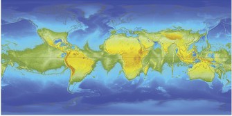
This would happen as the equatorial aquatic surplus would rush towards both poles, submerging much of the land mass towards either extremity, eventually creating an equatorial megacontinent that would ring the earth and thus separate both polar oceans.
What a strange new world this would be. As the earth would stop rotating (but presumably still circle the sun), one night-and-day cycle would last an entire year. The new continent ringing the globe (2) would include a large part of current Mid-Atlantic, Indian and Mid-Pacific seabeds, perhaps re-emerging legendary continents like Mu, Atlantis and other lands lost beneath the waves.
Most of North America would drown, a rump US still jutting out into the Northern Ocean. Of Europe, only Andalusia would remain (plus a few scattered Alpine, Pyrenean and Balkanic islets). Russia: gone. Central Asia: gone. North Africa would actually gain some land, but Afghanistan and Tibet would no longer be landlocked.
The southern hemisphere would fare a lot better: a lot less land to be lost there in the first place. Australia has to see Tasmania go, but gets a land bridge to Papua and the wider world – and that’s been a while, as attested by the development in isolation of its unique marsupial fauna. Speaking of which. Provided any animals (and humans) survive the Great Stoppage (3), it would be interesting to see what living on a single land mass does to the diversity of the natural world.
Because the Northern and Southern Ocean are now separate from each other, and since both basins have different capacities, there will be two sea levels, with the Southern Ocean’s zero elevation 1.4 km (0.9 mi.) lower than the Northern one.
As mentioned earlier, this scenario is far-fetched, but the theory behind it is not without its relevance to the real world – which is slowing down, slightly but measurably so. About 400 million years ago, the earth rotated 40 times more around its axis for every revolution around the sun – meaning that an earth year had over 400 days, and that oceans bulged even more at the equator than today.
Many thanks to John O’Brien, Thomas McColgan, Paul Drye and Eirik B. Stavestrand for sending in this map. The science (and the computation) behind it is explained in great detail by Witold Fraczek, who devised it at the Environmental Systems Research Institute (ESRI) here on the ESRI website.
Strange Maps #475
Got a strange map? Let me know at strangemaps@gmail.com.
(1) As Klaatu, in the 2008 remake of the 1951 original sci-fi horror movie of the same name as the title of this post.
(2) What would it be called? Pangaea – again? Ringland? Equatoria?
(3) This sounds like a British remake of (1)