Why it’s Always Chile in Norway
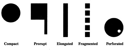
Do Norwegians feel curiously at home in Chile, and vice versa? Do South Africans have a strange affinity with Italians? And Filipinos with Maldivians? They should, at least if they’re map nerds: each lives in a country with a territorial morphology [1] that closely resembles the other’s.
Although they’re on opposite sides of the globe [2] Chile and Norway are each other’s type, morphologically speaking: elongated to the extreme.
From east to west, Chile on average is just 150 miles (240 km) wide, which is the distance from London to Manchester, or New York to Baltimore. But from north to south, it measures 2,700 miles (4,300 km), which takes you from London to Tehran; or New York to Los Angeles. This makes Chile the world’s most stretched-out country – 18 times longer than it is narrow.
Norway is much smaller than Chile, but still the longest country in Europe. The country extends 1,100 miles (1,750 km) north to south, with an average width of 270 miles (430 km). Which makes Norway only 4 times as long as it is narrow [3].
South Africa and Italy? Perhaps the first one gives it away: the nation on Africa’s southern tip bears a faint resemblance to a bowling ball, what with that large enclave in its middle: the totally independent Kingdom of Lesotho [4] is totally surrounded by the Republic of South Africa. You need to zoom in quite far to see something similar in Italy, but then you’re rewarded with two examples: Vatican City, in Rome, and the Republic of San Marino [5], straight north from Rome, near Rimini on the Adriatic coast.
‘Perforated’ is perhaps the second-most recognisable of the 5 types of territorial morphology devised by political geographers, after ‘elongated’. The others are ‘compact’, ‘fragmented’ and ‘protruded’ (a.k.a. ‘prorupt’ [6]).
Fragmented states typically are island archipelagos, like Japan, Indonesia, the Philippines or the Maldives. Prorupt states are quite rare, but the Malay Peninsula is shared by two – Burma and Thailand. The least remarkable morphology also is the most common one: compact states are unperforated, non-fragmented, and lack prominent protrusions. When considering shape, size doesn’t matter: China is compact, for example, while Italy is not (come to think of it, it’s both perforated and elongated).
The Five Types of Territorial Morphology sounds like a fun parlour game, at least in cartophile circles (is Portugal compact or elongated? Is or isn’t Somalia prorupt? Does New Zealand qualify as fragmented?) But there is a serious, geopolitical concern behind this attempt at classification. For a country’s shape has a profound impact on its economic success, and even its political viability.
Case in point: Lesotho. Being completely surrounded by another country does your economy no good. Four out of 10 Lesothans live on less than $1 a day, and the country ranks 160th (out of 187) on the UNDP’s [7] Human Development Index. Even compared with the wildly unequal society that is South Africa, Lesotho stands out as a pocket of deprivation.
The country’s economic misery is compounded by an HIV pandemic, which is all the more difficult to combat because of the Lesotho’s isolation and limited means. One in 4 adult Lesothans is infected – one of the highest rates in the world [8] – and one estimate counts 400,000 Aids orphans for a total population of 2 million. Life expectancy is variously reported to be under 50, about 42, or as low as 34. In 2010, a petition for South Africa to annex the country garnered the signature of 30,000 Lesothans, but South Africa as yet has refused to make Lesotho its 10th province.
Another morphology, another set of problems. Fragmented states often experience great centrifugal pressures, with separatism affecting their outlying fragments. This is true of the Philippines, the central government of which only last October concluded a peace deal with the Moro Islamic Liberation Front [9], which had waged a separatist guerilla on the southern island of Mindanao. Something similar has been endemic in Aceh, at the western tip of Sumatra, where both the Dutch colonisers and the Indonesian central government have battled insurrections and rebellions.
Indonesia has had to contend with a few other centrifugal forces, one of which actually succeeded (and seceded): East Timor, which in 2002 became the 21st century’s first independent state. In the process, East Timor changed from being a fragment of a fragmented state to being the solid core of a compact state [10].
The implicit message of the Five Types is that compact is best, avoiding the logistical problems posed by the elongated, fragmented, perforated and protruded types. But is that really so? Cambodia, vaguely resembling a sea shell, is a fairly compact nation. That didn’t stop it descending into murderous anarchy when the Khmer Rouge took power in the mid-1970s, installing a regime that took its cue from the crazier aspects of Maoist Communism. China itself, morphologically compact, is torn between its high-performing coastal zone, an underdeveloped hinterland, and a far west forever rumbling with the distant thunder of separatism [11].
Perhaps these morphologies are the star signs of geopolitics: a fairly random way to categorise states and territories, which may or may not behave like the categories they’re placed in predict they will. Maybe the Five Types are a parlour game after all…
The first map was taken here from Maps101. The second map was taken here from the page of Dr. Jean-Paul Rodrigue, professor in Transport Geography at the Department of Global Studies and Geography at Hofstra University on Long Island (NY).The third one taken here at Studyblue.
Strange Maps #595
Got a strange map? Let me know at strangemaps@gmail.com.
[1]The study of the structure of territories (from the Greek morfè (‘form’) and logos (‘study’); not to be confused with geomorphology, which studies the structure of land masses. The critical difference between both disciplines are the man-made borders that divide land masses into territories. ↩
[2] The two nation’s capitals, Oslo and Santiago, are 7,900 miles (12,700 km) apart. The maximum distance between two locations on Earth, half the circumference of the Earth at the equator, is 12,450 miles (20,036 km). ↩
[3] Then again, if we consider Norway at its narrowest – 2.7 miles (4.3 km) at Tysfjord in mid-Norway – then Norway is over 400 times as long as it is narrow. If we do the same for Chile (which is only 56 miles (90 km) wide near the city of Illapel), the outcome is that Chile is ‘only’ 48 times as narrow as it is long. ↩
[4] Present occupier of the throne is King Letsie III. His predecessor Moshoeshoe I in 1868 obtained British protection for his Basutoland against further encroachment by the Orange Free State, thus denying that Boer republic access to the sea. The protectorate achieved independence from Britain in 1966. ↩
[5] The Vatican as a sovereign papal state is a fairly recent construct, the result of the Lateran Treaty, negotiated in 1929 between Mussolini’s fascist Italy and the Church, represented by Eugenio Pacelli – the older brother of Francesco Pacelli, later to become Pope Pius XII (r. 1939-1958). San Marino, on the other hand, is often considered the oldest state in the world: an unbroken tradition stretches back to its founding as a monastic community in 301 AD by Saint Marinus. Upon his death, he is supposed to have said: I release you from both men. This obscure phrase was interpreted by his followers, somewhat self-servingly, as freedom from both the Emperor and the Pope – and thus the foundation for the Most Serene Republic itself. ↩
[6] Literally ‘burst forth’. In political geography: territories consisting of major part, and a minor part, connected by a short corridor. The ultimate example of a prorupt territory is fictional: a map of an imagined Netherlands with a colony in the Balkans, connected to the ‘motherland’ by a narrow corridor. More about that in the intro to #525. Map seen once, never found again. Update 23 March 2016: now found! ↩
[7] The United Nations Development Programme is the global development network run by the U.N., spanning 177 countries. ↩
[8] Nine out of 10 countries worst hit by HIV/Aids are in southern Africa, with adult prevalence rates per country,in order of descent: Swaziland (26%), Botswana (24%), Lesotho (23%), South Africa (18%), Namibia (15%), Zimbabwe (15%), Zambia (15%), Mozambique (12%), Malawi (12%) and the Central African Republic (6%). ↩
[9] I really don’t see what’s funny about that. Order at the back of the class! ↩
[10] At least on this map. In fact, the situation is a bit more complicated. East Timor not only occupies the eastern part of the island of Timor, it also controls Oecusse, an exclave in the western, still Indonesian part of the island. ↩
[11] Uyghur nationalism in East Turkestan, and Tibetan nationalism in Tibet itself, and adjacent parts of China with significant Tibetan populations. ↩


