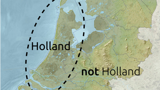
Belgium and the Netherlands swap land without a single shot being fired
On 28 November, the Royal Palace in Amsterdam hosted a remarkable land-swap ceremony. With their respective sovereigns looking over their shoulder, the Belgian and Dutch foreign ministers signed a treaty that formalised a territorial exchange between their two countries.
As a rule, countries are nothing if not territorial – in both senses of the word – and borders only change after a high price in death and destruction has been exacted. But Belgium and the Netherlands are adjusting a riverine stretch of their common border without a single shot fired.
There were smiles all round at the Palace, even though the exchange is not entirely equitable. The Netherlands are getting the better deal: gaining about 35 acres of Belgian land, while the Belgians only get about 7 acres in return. But the inconvenience resolved by the exchange is more important to either side than that minor imbalance.
The exchange had been a long time coming. Strange Maps reported on the issue in December 2013. That post is reproduced here below, with the addition of a new map of the area.
+ + +
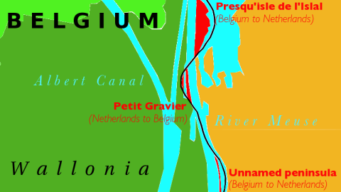
A combination of sex and drugs (and possibly rock ‘n roll) is forcing two governments to change the border that divides them. The Presqu’ile de l’Islal, a small Belgian peninsula stranded on the Dutch bank of the river Meuse, is to change hands to eliminate a zone that is, to all practical effects, quite literally beyond the law.
Because of its political status, the uninhabited peninsula is off limits for Dutch police. And because of its geographic isolation, it is out of reach for their Belgian colleagues. These circumstances conspire to make the peninsula a sanctuary for unlicensed sunbathing, loud bacchanalia and unrestricted drug dealing.
The Islal Peninsula is small, no more than 15 hectares (37 acres) in size, or to put it in terms easily understood on either side of the river: about 28 soccer pitches. Yet few locals will have heard of it, perhaps because it’s situated in an area already rich in border peculiarities.

Areas shaded red to switch from Belgium to Netherlands, area shaded blue from Netherlands to Belgium.
The Meuse, which springs in France and flows north through Belgium, becomes a border river about 5 kilometres south of the peninsula at Lixhe, where the right bank turns Dutch. Literally a few metres north of the peninsula, both banks become Dutch, keeping Maastricht inside the Kingdom of the Netherlands. The circular land border separating that city from Belgium is 2.4 kilometres away from its ancient city walls – about the distance of a mid-19th-century cannon shot. Just north of Maastricht, the Meuse resumes its function as border river for another 40 kilometres. Beyond that, both sides of the river again go Dutch, and the Meuse eventually bends eastward to its final destination, the port of Rotterdam.
The language border that divides Belgium in a Dutch-speaking north (Flanders) and a French-speaking south (Wallonia) joins the river’s course between Maastricht and Lixhe, briefly to become an international border. On the west bank, the tiny Wallonian hamlet of Petit Lanaye blocks Flemish access to the river, if only by about 200 metres. As if in compensation, the Flemish exclave of Voeren, wedged between Wallonia and the Netherlands on the other bank of the river, touches the Meuse for about 300 metres.
So how did Belgium end up with this spit of land, sticking out into the Meuse from the wrong side of the river? The border marker that indicates the territorial divide between the peninsula’s Belgian north and its Dutch south is engraved with a date: 1843. Although Belgium traces its independence from the Netherlands to 1830, it took quite a few military campaigns, economic blockades and political negotiations to reach a settlement.
In 1842, Belgium grudgingly abandoned its claims to the eastern parts of Limburg and Luxembourg: the western halves of these areas became Belgian provinces, the rest fell to the Netherlands. Eastern Luxembourg became a Grand Duchy – nominally independent, but ruled by the Dutch king. Although the royal lineage of both countries has since diverged, they still use a variation of the Dutch national flag, and of its national anthem. Eastern Limburg became a Dutch province, and the Meuse the convenient border – except for where it flows through Maastricht: that city held out against the Belgian rebels, and was granted entirely to the Netherlands.

Rivers are frequently used as international borders, for what seems like an obvious reason: they’re already there, eliminating the need to negotiate and demarcate a new border. Hence the Rio Grande, separating the US and Mexico. Or the Oder and Neisse, between Poland and Germany. Or the Yalu, keeping China and North Korea apart.
However, this negates another, more ancient function of rivers – they are humanity’s oldest highways. Rivers facilitate commerce and communication both between upstream and downstream, and between east and west bank. Plus, rivers are dynamic entities: wait long enough, and they shift their course. What then happens with the border? Does it stay in place, a fossil record of an ancient riverbed, or does it follow the flow of the water, shifting the border to one country’s advantage, and another’s disadvantage?
Questions like these have frequently led to territorial disputes, even armed conflicts [1]. Which is why river borders need to be defined very precisely. Typically, the actual borderline follows the thalweg – a German word denoting the line connecting the lowest points in the riverbed – instead of the middle of the river. Other options are for the border to run exactly down the middle of the river’s width, for it to be on either bank of the river (granting the entire river to one of both border states), or for the entire river to be a condominium [2].
Each of these options is fraught with problems. The problem in this case, a classic thalweg border, is not that the river has shifted of its own accord, but that it has been rectified to facilitate shipping. Maastricht and especially Liège, just south of the border in Belgium, are busy inland ports, close to the junction of the Meuse with the Albert Canal, which connects the sea port of Antwerp with the Belgian interior.
The problem is, or rather was, that the river’s meanders along this stretch proved an serious obstruction to shipping. So the Meuse was rectified, between the 1960s and the 1980s, to allow ships of a certain tonnage (a gentlemen never asks how much) to access the Meuse from the Albert Canal. These works eliminated a formerly very bendy stretch of river, which stranded bits of Netherlands on the Belgian, west bank of the river, and bits of Belgium on the Dutch, east bank of the river.
During and after the rectification, talks were started between both countries to bring their border in line with the new riverbed. But in the 1980s, local politics on the Belgian side of the border were highly explosive: Flemings and Walloons argued about political control over the Flemish exclave of Voeren (Fourons in French), with French-speakers campaigning to return the exclave to Wallonia. The times were not ripe to propose the loss of more Walloon territory, however small, uninhabited and inconveniently located.

In 2011, sanity prevailed. On the insistence of the Dutch authorities, fed up with the nuisance caused by the peculiar status of the Islal Peninsula, negotiations were restarted. Said Egbert Hanssen, spokesperson for the Dutch province of Limburg:
“The nature reserve on the peninsula has become a meeting area for the gay community, who use the area for nudism and occasionally exhibit inappropriate behaviour. They have parties in the area, and leave a lot of refuse in the reservation. But the Dutch police can’t do anything about this, as the area is still officially Belgian. Inversely, the Belgian police can’t really effectively control the area, as it has to make a giant detour to get there”.
Mr. Rompelberg, the local tenant farmer, has had his fence destroyed more times than he cares to count. Each complaint to the Visé police goes unheeded: the only way they could make it over in time to catch the culprits would be by river speedboat. Which they lack.
An ad hoc committee, comprising the mayors of the two towns involved (Visé in Belgium, Eijsden in the Netherlands) and government officials from either country have now agreed to a transfer of territory. Two bits of Belgium stranded on the Dutch bank of the Meuse would be transferred to the Netherlands: the Islal Peninsula, and a much smaller, unnamed peninsula to the south. In exchange, one tiny morsel of Dutch territory called Petit Gravier, shipwrecked on the west bank of the river, would become Belgian. The Dutch have even agreed to pay 10% of the total cost of €64 million for the fourth lock of Lanaye, now being built in the area. Marcel Neven, the mayor of Visé, remains stoical about his town’s loss of territory:
“Yes, we’re losing a beautiful area; a paradise for birds and plants. But few of our citizens have ever been there, because it’s so difficult to reach, for lack of a decent road. A parliamentary commission visiting to study the situation couldn’t even reach the peninsula”.
Perhaps they just weren’t as determined as the sex fiends and drug hounds monopolising the area, Neven seems to imply:
“In this day and age, the international border doesn’t stop anyone from our city from going for a walk there. And it’s only logical for a border river to have one bank entirely in one country, and the other bank in the other country. So it’s only normal that principle that the Meuse should mark the Dutch-Belgian border should be maintained here as well. This should have been arranged years ago”.
The Belgian side agreed to the transfer on one condition: that the area’s status as a nature reserve be maintained. According to Albert Stassen, District Commissioner on the Belgian side,
“the peninsula at present is under the jurisdiction of the Walloon Department of Forests and Wildlife, but is already being managed by Het Limburgs Landschap, the Dutch wildlife association that manages De Eijsder Beemden, the adjacent nature reserve in the Netherlands”.
The nature reserve is home to a band of koniks – a breed of semi-feral Polish horses – and lies next to a string of river lakes which in summer are a popular recreational area.

The new border will again follow the thalweg of the Meuse, the new one, this time. When the actual transfer of territory will take place is as yet unknown. Officials for the Belgian and Dutch foreign ministries are preparing the dossiers for their respective governments, after which the proposals will need to be ratified by both countries’ parliaments.
So, will 2014 see the first border change for Belgium in almost a century [3]? If the federal parliament in Brussels votes yes, it will violate the spirit and the letter of at least one version of the Brabançonne, the country’s national anthem:
Never shall we cede even the smallest plot of land / If but one Belgian, be he Fleming or Walloon, remains alive.
Except, it seems, if that plot of land is used for sex parties and drug dealing – a possibility probably overlooked by the anthem’s composers.
UPDATE – Below a detailed map of the border changes, which also involve straightening out a few kinks in the course of the border on the river itself – a remnant of its former pathway.

Aerial map of the border zone taken from this page at the Visé city desk of the Walloon newspaper publisher Sudpresse. Map above provided by E. Berns to the Borderpoint Yahoo Group. Other maps courtesy of Ruland Kolen.
_________
[1] E.g. the dispute between Iran and Iraq over the exact course of their border along the mouth of the Shatt-al-Arab, which contributed to the outbreak of the Iran-Iraq War (1980-1988). ↩
[2] The rarest of options – for an example, look no further than just a few dozen kilometres south, to the riverine border between the Grand Duchy of Luxembourg and Germany. More on that in this episode of Borderlines. ↩
[3] In 1919, Belgium annexed the German territories of Eupen and Malmédy as part of its compensation for Germany’s invasion in 1914, and the consequent horrors of the First World War. The Netherlands similarly annexed a few areas of Germany after the Second World War, but gave most of them back after a few years. ↩