How Europe’s newest bridge unites (and divides) the Balkans

- The end of Yugoslavia created several border anomalies in the western Balkans.
- One is the Neum bottleneck, where two international border crossings are only a few miles apart.
- A new bridge bypasses Bosnia’s only port and unites Croatia, but is it all good news?
Where international borders meet, building a bridge is more than just an engineering project. It’s a matter of geopolitical consequence.
Take for instance the Øresund Bridge, linking Denmark to Sweden since 2000. It gave rise to a transnational conurbation — sometimes infelicitously dubbed CoMa (for Copenhagen and Malmö) — not to mention an acclaimed Scandi Noir TV series, simply called The Bridge.
Or consider the Kazungula Bridge, inaugurated in May last year. Built across a place in the Zambezi River where four southern African countries almost touch, the $259-million structure has the potential to transform a four-way backwater into a corridor of opportunity. (See Strange Maps #1091.)
A bridge built by Brussels and Beijing
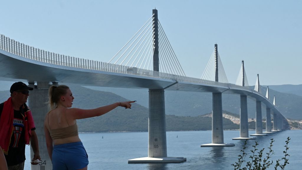
The most recent example is the Pelješac Bridge, which ceremoniously opened for traffic this Tuesday. Unlike the aforementioned, this bridge was built to better separate two countries rather than to unite them. It bypasses Bosnia-Herzegovina’s toehold on the Adriatic and links two non-contiguous parts of Croatia.
In so doing, the 1.5-mile (2.4 km) connection is reconfiguring the landscape, physical and political, of the western Balkans, ahead of Croatia’s accession to the Schengen Area. And the EU-financed, Chinese-built bridge is the latest, most visible sign of both Brussels’ and Beijing’s interest in the region.
The EU financed the project to the tune of €357 million (out of a total cost of €526 million). From its largest ever infrastructure investment in Croatia, the EU gains a better-connected member state, with increased economic opportunities, in particular for tourism. The China Road and Bridge Corporation won the international tender to construct the six-pyloned, cable-stayed bridge. Critics fear Beijing is seeking influence through infrastructure.
The bridge shortens travel time by 37 minutes, but that hardly justifies such a massive investment. Its actual value is that it cuts Bosnia out of the traffic equation. When Yugoslavia was still a thing, that would have seemed an expensive absurdity. Only after 1991, when Croatia and Bosnia-Herzegovina became independent neighbors, did their newly international common border lead to a few weird consequences.
Bizarre Balkan borders
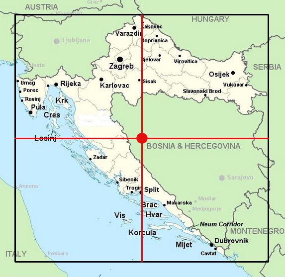
Border weirdness #1: Croatia’s geographic center is in Bosnia
Look at a current map of the western Balkans, and you’re immediately struck by Croatia’s crescent-like form. Bosnia serves as the wedge that separates, at their furthest points in the east, the two tips of that crescent by about 270 miles (430 km). A bizarre consequence of Croatia’s weird shape is the fact that its geographic center lies outside of Croatia itself — to be precise, near the village of Drinić in Petrovać, one of the least populated municipalities of the Republika Srpska, Bosnia’s Serbian half.
Border weirdness #2: Bosnia has the world’s shortest coastline
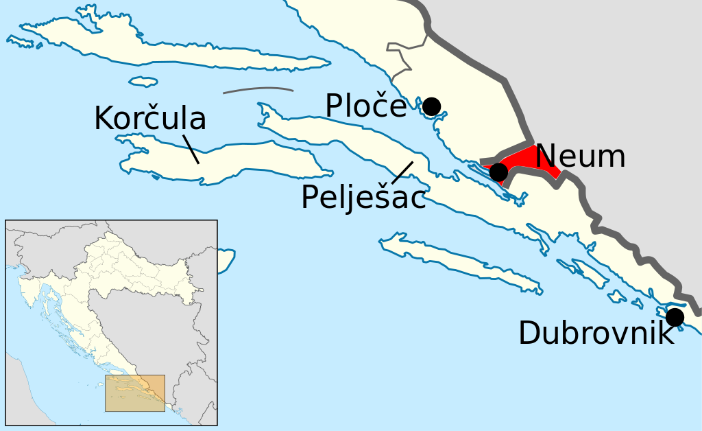
If you think Bosnia-Herzegovina is landlocked, you’re not looking hard enough. Zoom in on the area near the bottom of the Bosnian triangle, and you’ll see a town called Neum (pronounced NAY-oom). That town’s 12 miles (20 km) of shoreline on the Adriatic constitutes Bosnia-Herzegovina’s only access to the open sea. Not counting dependencies and microstates, that makes Bosnia’s coast the shortest of any country in the world. (In case you’re wondering: Jordan is the runner-up, with 16 miles (26 km), DR Congo third with 23 miles (37 km).)
This anomaly has existed since the Treaty of Karlowitz (1699), in which the Republic of Ragusa granted Neum to the Ottoman Empire. This was to prevent an overland invasion of Ragusa by its neighbor and rival, the Republic of Venice.
Border weirdness #3: Neum cuts Croatia in two
The Ottoman, Venetian, and Ragusan empires have evaporated, but the Neum anomaly has survived. Before 1991, this was not a problem. But since the breakup of Yugoslavia, Neum cuts independent Croatia in two, separating the bulk of the country from Southern Dalmatia, which includes the Pelješac peninsula and, a bit further south, the medieval walled city of Dubrovnik (historical name: Ragusa), Croatia’s main tourist destination.
Not one international border crossing, but two
European route E65 connects Dubrovnik to the rest of Croatia over land, but that road passes through Neum — which means not one but two international border crossings in the space of just a few miles.
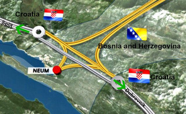
Croatia and Bosnia had reached an agreement to minimize delays at the crossings, but that went out the window when Croatia joined the European Union in 2013. All of a sudden, both Neum crossings became external borders of the EU, which meant mandatory checks and long lines.
That situation would only get worse when Croatia joins the Schengen Area, a zone consisting of 26 European countries that have abolished passport checks at their borders. Croatia is likely to join in 2023. While that means no more checks on borders with Schengen countries, it means even stricter ones on borders with non-Schengen countries. And, hence, even longer lines at Neum.
The Pelješac Bridge is an expensive way to avoid all that, and it will likely speed up Croatia’s entry into the Schengen Area.
Why Bosnia is not happy with the bridge
At the bridge’s opening ceremony, European Commission Vice President Dubravka Šuica emphasized how much it symbolizes “the essence of the EU’s existence, in bridging and connecting, in creating permanent links by building them on common values.” That is, of course, only half the story — because it fails to mention that Bosnia is simply cut out of the picture, as if it were a nasty ex.
The Bosnians, predictably, are not happy with the bridge. This is not only because it bypasses Neum, depriving it of traffic and commerce, but also because they feared it would cut off Bosnia’s only access to the sea. To address that concern, Croatia agreed to raise the height of the bridge from 144 feet (44 m) to 181 feet (55 m), which will allow high-tonnage vessels to sail into Neum.

The bridge will give the 90,000 Croats who live in Southern Dalmatia easier access to the Croatian “mainland”, which has all sorts of social, economic, and political benefits for their region, for Croatia itself, and for the EU.
Meanwhile, Bosnia remains firmly outside of the EU. In fact, it is not even a candidate for accession. The EU merely recognizes Bosnia as a “potential candidate.” Negotiations have not even started, which means accession is many years away, if it happens at all. The country’s political system is an impractical cohabitation of former enemies, and predictions of its collapse seem increasingly credible — and with it, a relapse into civil war.
It may yet turn out that the Pelješac Bridge is the answer to the wrong question. Instead of, “How do we avoid Bosnia?” it should perhaps have been, “How do we include Bosnia?”
Many thanks to Nimbo Maps for alerting me to this map.
Strange Maps #1161
Got a strange map? Let me know at strangemaps@gmail.com.
Follow Strange Maps on Twitter and Facebook.
