See the Sun Set on Europe
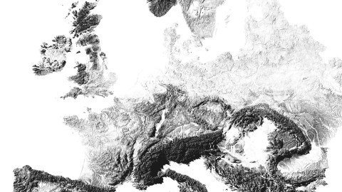
One theory about the origin of the name ‘Europe’ is that it means ‘sunset’ (1) – Asia, by the same token, would mean ‘sunrise’. In that case, here we have a sunset map of sunset-land.
Imagine the westering sun disappearing over the horizon on the left hand side of this map. These are the shadows cast by the hills and mountains of Europe.
Darker means more mountainous; lighter equals flatter. Hence the near-invisibility of the Netherlands, on the western edge of the Northern European Plain that extends all the way into Russia.
Other remarkably flat areas include the Hungarian Plain and the Po Valley in northern Italy, both surrounded by mountain chains.
The darkest shadows – and the highest mountains – can be found in the Alps (clearly the result of Italy pushing into Europe). The Balkans are almost completely mountainous, the Carpathian mountain range writes a Z for Zorro across the map of Eastern Europe, from southern Poland to the Romanian-Bulgarian border. The Pyrenees form the Franco-Spanish border, but extend almost all the way to the northwestern extremity of the Iberian peninsula.
Mountains often prefigure borders: that Z shape in Romania marks the edge of Transylvania. The mountainous peninsula in the west of Great Britain is contiguous with Wales. The zone where Belgium’s flat north transforms into its hilly south, is almost exactly the same as the language border between Dutch and French. And Switzerland’s independence has more to do with its mountainous inaccessibility than with the convenience of its banking system.
This sunset map of Europe is based on actual topographical information, but is a computer-generated image rather than an actual snapshot by satellite. That would be impossible: those mountains and plains are draped over a globe, so by the time the shadows start lengthening in Spain, night has long fallen in the Balkans.

Strange Maps #858
Got a strange map? Let me know at strangemaps@gmail.com.
(1) See also #331
