Why Swiss maps are full of hidden secrets
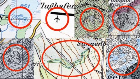
Credit: Swisstopo
- The Swiss are not known for their sense of humor, but perhaps we’ve not been looking hard enough.
- Over the decades, Swiss cartographers have sprinkled plenty of “Easter eggs” across otherwise serious maps.
- The oldest one, a naked lady, has been removed — but the marmot, the haunted monk, and others are still there.

Swiss humor. Now there’s two words you don’t often see together. In fact, Google Trends lists zero occurrences of the phrase between 2004 and now. Even “German humor” produces a graph (albeit a rather flat one). But not only is there some evidence that Swiss comedy does exist, it might just be that being well-hidden is kind of its thing. Find it and laugh. Or don’t, and the joke’s on you!
That evidence, as it turns out, is cartographic. The Swiss Federal Office of National Topography, Swisstopo for short, is a decidedly serious institution. Many serious things — time and money, for starters — depend on the accuracy of its maps. In the case of its mountain maps, actual lives hang in the balance. Yet in decades past, the austere institute’s maps have served as the canvas for a series of in-jokes among its more fun-loving cartographers.
These mapmakers played a game of wits against their superiors, the ones whose duties included checking the maps before publication. Over the years, the cartographers managed to slip in — on maps that were supposed to contain only dry topographic facts — drawings of an airplane, a fish, a marmot, a mountaineer, a face, a spider, even of a naked lady. Once discovered, these humorous additions were removed without pardon. At least, that’s how it used to be.
Either way, it doesn’t matter. Swisstopo is defeated by its own thoroughness. Its map page allows you not just to zoom in and out of the most recent maps but also to browse historical maps and thus revisit these “Easter eggs” that prove, however obliquely, the existence of a sense of humor among the mountains of Switzerland.
The plane that disappeared — twice

In 1994, an anonymous cartographer at Swisstopo included an airplane in this map of Kloten, the international airport of Zürich. While it may seem only natural for airplanes to show up at airports, that is normally not the case on topographic maps.
The error remained undetected until a revision of the map in 2000, when the offending craft was erased. However, the plane reappeared on the 2007 map at exactly the same spot – the tarmac before Gate A – only to vanish again in 2013.
The Naked Lady of Künten

Possibly the oldest topographical Easter egg, and the current record holder for the longest-lasting one, is the Naked Lady of Künten. First appearing on the topographical map of 1954, the reclining figure wasn’t discovered until 2012. Admittedly, without head, arms and feet, she is hard to spot. Her odalisque-like forms are suggested by the curvature of a stream and an elongated green patch indicating vegetation.
The world — or at least that bit between Eggenrain and Sunnenberg — was put to right again in the 2013 edition of the local map. But it’s still easy to see how that particular distribution of topographic features could have inspired a lonely 1950s cartographer to pencil in something that wasn’t there.
A Swiss fish in a French lake

It was never discovered who reshaped the aforementioned landscape feature into a female form. But the younger generation of Easter-eggers is known by name.
In 1980, Werner Leuenberger even went international. He drew a fish at the southern end of the Lac de Remoray, a small lake just across the Franco-Swiss border. The fish felt right at home among the lines marking out the area as swampy. However, it was caught five years later, and has been left off the map since 1986.
Attack of the giant Eiger spider

In 1981, Othmar Wyss inserted a spider near the top of the Eiger, one of Switzerland’s most iconic Alpine summits, at a location actually known by mountaineers as quite dangerous.
The giant spider survived for six years in the freezing cold. The snowfield that made up the spider’s body — and made the northern approach of the Eiger so hard — has apparently also disappeared in the intervening years.
Haunted monk trapped in a map

A rock formation on a slope of the Harder Kulm, a mountain near Interlaken, looks like a face. This is the Hardermandli, or “little Harder man.” Legend has it that he was a lecherous monk, condemned to look down on the place where he chased a girl to her death.
Cartographer Friedrich Siegfried extended the curse to cartography, for since 1980 and until this day, the Hardermandli also lives on the map.
Beats waiting for the Italians

For the 1997 map update, Mr. Siegfried etched the likeness of a mountaineer on the Italian side of a mountain slope near Val Müstair. Reportedly, he got tired of waiting on the data for the area, which his Italian counterparts were slow to provide, so he found a creative way to plug the gap. Topography, like nature, also abhors a vacuum, apparently.
Swisstopo seems to have taken to heart the cartographer’s slight against his Italian colleagues, because the mountaineer still appears on the contemporary map, in 1:100,000 scale at least.
The marmot of the Aletsch glacier

Swisstopo’s most famous map gag — or at least the most recent one to be revealed, in 2014 — is the marmot, which has been hiding in a rock near the Aletsch glacier since it was put there by cartographer Paul Ehrlich in 2011, shortly before his retirement. The marmot is still there, and perhaps it and its fellow map oddities may be allowed to survive.
On its website, Swisstopo says that “these hidden drawings do not affect the accuracy and level of detail of our maps, nor on the safety and security of their users. They merely add a note of mystery to our nation’s maps.”
Are there any other gags hidden in the official maps of Switzerland? Swisstopo itself claims it has no knowledge of any other cartographic oddities. But knowing and not telling, that’s exactly the kind of thing they would find funny, isn’t it?
Strange Maps #1085
Got a strange map? Let me know at strangemaps@gmail.com.
Follow Strange Maps on Twitter and Facebook.
