The World’s First Tutulemma

Ever heard of an analemma? Unless you’re an astronomer: probably not. It’s the strange figure-eight shape that maps out the Sun’s annual trajectory across the sky. But even astronomers may not have heard of a tutulemma: an analemma that includes a solar eclipse.
If you have a globe at home, spin it towards the Pacific Ocean. There’s a good chance you’ll find that figure-eight-shaped trajectory there, plonked down in the vast expanse of the world’s biggest body of water, where it doesn’t smother any islands. With its extremities pinned to the Tropics of Cancer and Capricorn, it looks a bit like a quarter-turned lemniscate (a.k.a. infinity symbol). On the particular model pictured here, the legend near the object reads:
ANALEMMA showing the SUN’S DECLINATION for every day in the year. Also the EQUATION OF TIME.
So what does the analemma actually do? As the legend says, two things – which together also explain its shape.
First, the Sun’s declination. It’s no coincidence that the top of the figure eight touches the Tropic of Cancer and its bottom the Tropic of Capricorn. At 23°26’16” north and south respectively, these two circles of latitude mark the boundaries of the zone on either side of the Equator [1] where the Sun can be seen directly overhead, at a perfect vertical angle. Due to the Earth’s axial tilt, the location of that perfect angle varies throughout the year. It is this shifting of the Sun’s rays that causes the seasons.

The analemma on a globe in Vienna’s Globenmuseum (Image by Politikaner, distributed under the ShareAlike 3.0 license. Found here at Wikimedia Commons)
Take a look at the analemma on the globe: the months and dates wrapped around its hourglass figure indicate at which date and latitude to expect the Sun’s rays directly overhead.The southernmost point of the analemma is December 20th, around which time the Sun’s rays shine down straight on the Tropic of Capricorn, after which the Earth’s axial tilt moves that vertical line of sunshine north again. The shortest day of the year will be around this date, at least in the Northern Hemisphere. Inversely, it will be the longest day in the Southern Hemisphere.

The analemma in close-up: a miniature almanac (Image by Ted Cousins, reproduced with kind permission. Taken here from the Kronometric blog)
The same happens at the top of the analemma – in reverse: the longest day in the Northern Hemisphere (and the shortest in the Southern one) will be around June 20th, because that’s when the Sun’s vertical rays hit their northern limit, before turning south again.
That explains the vertical axis of the analemma, but not its rollercoaster curves along its horizontal axis. If the Sun’s rays hit the same latitude on corresponding dates on either half of the year, why isn’t the Sun’s seasonal shift between winter and summer solstices not indicated by a simple, straight line?
Well it would be, if the Earth revolved around the Sun in a perfect circle. But it doesn’t – it’s an ellipse. Because of this elliptical orbit, a planet will move faster when closest to the Sun (i.e. in its perihelion) and slower when it is furthest from the Sun (aphelion). Which is why there is a second part to the legend – the equation of time.
This term refers to the difference between the time on your clocks, and the time as indicated by the position of the Sun. Our timekeeping is based on the Sun, but not synchronous with it. The best-known example of this occurs every leap year, when we add February 29th to the calendar to account for the fact that a solar year lasts a quarter of a day longer than the 365 days we conveniently employ to fill out a calendar.
Similarly, there is a difference between apparent solar time (it’s noon when the sun appears at its highest point) and mean solar time (it’s noon when the clock strikes twelve). For solar days are almost never exactly 24 hours long. This only happens on four days, linked on the globe analemma by the axis that touches the dates at its top and bottom (June 20th and December 20th) and the knot where its lines cross (August 30th and April 14th).
For the rest of the year, solar days vary in length from 23 hours and three quarters to 24 hours and a quarter. That’s what the analemma’s bulges indicate: by how much clock time is behind or ahead of solar time. The amount of variation is indicated by the measure placed over the knot. The biggest bulges are around November 3rd, when your watch will be about 15 minutes behind the Sun, and around 12 February, when it will be just over 15 minutes ahead.
This is just a thumbnail sketch of the wonderful miniature almanac that is an analemma – no doubt incomplete to the expert, but just about as much astronomy as a lay person can keep in their heads at any given time. But let’s leave the theory at that, and have a look at a few more practical implications of the analemma phenomenon.
Analemmata [2] aren’t just found on maps. You could also produce one yourself, in your own backyard. That’s exactly what a small subset of astrophotography enthusiasts has been doing. Main requirements: patience, punctuality and precision. And a steady camera tripod. Procedure: at a few dozen days spread evenly over an entire calendar year, take a picture of the exact same piece of sky at the exact same (solar) time of day – making sure that the entire extent of the analemma will be included in the finished image. Result: the by now familiar eight-shaped trajectory.

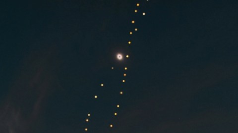
Analemma eclipsed: the world’s first tutulemma. (Image by Tunç Tezel, reproduced with kind permission. Found here at The World at Night).
If you were persistent enough to produce an analemma at the North Pole, it would be as upright as the one on the globe, also with the smaller loop at the top. But you’d only see the top half of the entire figure. The entire analemma is only observable between the Arctic and Antarctic circles. Go south, and the analemma will start to rotate. It will be completely horizontal if you photograph it at the Equator [3].
As the analemma continues to rotate as you go further south, the larger loop will gradually turn towards the top. At the South Pole, only the bottom half of the analemma will be visible – but because of the analemma’s rotation, it will be the same as the top half you observed at the North Pole!
Analemma photography is a fairly recent phenomenon. The first successful photo of an analemma on a single photo frame was taken from February 27th, 1978 to February 17th the next year by Dennis di Cicco, an amateur astronomer from New England. As on all analemma pictures, the Sun is highest during summer and lowest during winter. The analemma’s position is determined not only by the latitude at which the images are taken, but also by the time of day.
Digital photography has made it easier to create composite images, and consequently, the narrow field of analemma photography has witnessed a modest boom. Some examples on this page of NASA’s Astronomy Picture of the Day website.
The field appears new enough for its share of interesting firsts. As yet there is only one image in the subcategory ‘analemma including the total phase of a solar eclipse’. This image was started in 2005 by Tunç Tezel, a Turkish amateur astronomer, who managed to include an image of the total solar eclipse on 29 March 2006 that was visible from Side, on Turkey’s southern Mediterranean coast, where these images were taken. Incidentally, Venus was also visible during the totality – see the dot in the lower right of the picture.
This is the very first, and so far only analemma that includes a total solar eclipse. Since that description is a bit wordy, and since he was the first to produce it, Mr. Tezel used his discoverer’s prerogative to give it a name of his choosing. Will there be other tutulemmas? Undoubtedly: plenty of solar eclipses to plan for (see #158). But by mashing up the Greek word analemma with tutula – the Turkish word for eclipse – Mr. Tezel coined an astrological term that will be forever his.
See more of Mr. Tezel’s pictures in this gallery at The World At Night, a global pool of astronomy pictures and videos. Many thanks to Mark Feldman, who sent in this remarkable ‘Sun map’, as well as some background on Mr. Tezel’s image.
Strange Maps #697
Got a strange map? Let me know at strangemaps@gmail.com.
[1] The area is known, by the name of its limits, as ‘the tropics’.
[2] Yes, that is how the Greeks would like you to pluralize that word. Alternatively, analemmas will do.
[3] By now, you know enough to ruin the movie Castaway next time you see it: the analemma drawn on the cave wall is way too vertical. Tom Hanks is stranded on a tropical island, so it should be nearly horizontal.


